
Topografische Karte Bo'stonliq Tumani
Interaktive Karte
Klicken Sie auf die Karte, um die Höhe anzuzeigen.
Über diese Karte
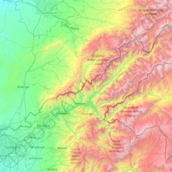
Name: Topografische Karte Bo'stonliq Tumani, Höhe, Relief.
Ort: Bo'stonliq Tumani, Provinz Taschkent, Usbekistan (41.22391 69.58909 42.29508 71.26909)
Durchschnittliche Höhe: 1.597 m
Minimale Höhe: 303 m
Maximale Höhe: 4.255 m
Andere topografische Karten
Klicken Sie auf eine Karte, um ihre Topografie, ihre Höhe und ihr Relief anzuzeigen.
Olmaliq
Usbekistan > Provinz Taschkent > Piskent Tumani
Olmaliq, Piskent Tumani, Provinz Taschkent, Usbekistan
Durchschnittliche Höhe: 571 m
Аксу
Usbekistan > Provinz Taschkent > Ohangaron Tumani
Аксу, Ohangaron Tumani, Provinz Taschkent, Usbekistan
Durchschnittliche Höhe: 2.479 m
X лет Узб ССР
Usbekistan > Provinz Taschkent > Bo'ka Tumani
X лет Узб ССР, Bo'ka Tumani, Provinz Taschkent, Usbekistan
Durchschnittliche Höhe: 309 m
Bekobod
Usbekistan > Provinz Taschkent > Bekobod
Bekobod, Provinz Taschkent, Usbekistan
Durchschnittliche Höhe: 318 m
Bekobod
Usbekistan > Provinz Taschkent > Bekobod
Bekobod, Provinz Taschkent, Usbekistan
Durchschnittliche Höhe: 317 m
Toshloq
Usbekistan > Provinz Taschkent > Quyichirchiq Tumani
Toshloq, Quyichirchiq Tumani, Provinz Taschkent, Usbekistan
Durchschnittliche Höhe: 370 m
Syrdarja
Usbekistan > Provinz Taschkent > Yuqori Qo'shtamg'ali
Syrdarja, Yuqori Qo'shtamg'ali, Bekobod tumani, Provinz Taschkent, Usbekistan
Durchschnittliche Höhe: 361 m
Qo'ng'irot
Usbekistan > Provinz Taschkent > Qo'ng'irot
Qo'ng'irot, Oqqorgon tumani, Provinz Taschkent, Usbekistan
Durchschnittliche Höhe: 347 m
Beshtut
Usbekistan > Provinz Taschkent > Beshtut
Beshtut, Bo'stonlik Tumani, Provinz Taschkent, Usbekistan
Durchschnittliche Höhe: 895 m
Aqmola
Usbekistan > Provinz Taschkent > Yuqorichirchiq Tumani
Aqmola, Yuqorichirchiq Tumani, Provinz Taschkent, Usbekistan
Durchschnittliche Höhe: 456 m