Geolokalisieren

Topografische Karte Nwoya

Interaktive Karte

Klicken Sie auf die Karte, um die Höhe anzuzeigen.

Über diese Karte

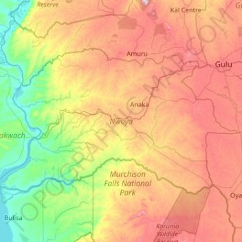
Name: Topografische Karte Nwoya, Höhe, Relief.

Ort: Nwoya, Nord-Region, Uganda (2.21947 31.33581 2.83771 32.36258)

Durchschnittliche Höhe: 910 m

Minimale Höhe: 613 m

Maximale Höhe: 1.395 m

Im Jahr 1991 wurden 37.900 Einwohner, im Jahr 2002 41.010 Einwohner gezählt. Im Jahr 2012 wurde die Distriktsbevölkerung auf 54.000 Einwohner geschätzt, die Zählung von 2014 ergab die jedoch den deutlich höheren Wert von 133.506 Einwohnern. Für 2020 wurden 236.000 Einwohner geschätzt.

Wikipedia (CC-BY-SA 3.0)

Andere topografische Karten

Klicken Sie auf eine Karte, um ihre Topografie, ihre Höhe und ihr Relief anzuzeigen.

Fort Portal City

Uganda > West-Region

Fort Portal City, West-Region, Uganda

Durchschnittliche Höhe: 1.525 m

Dodos

Uganda > Amuria

Dodos, Amuria, Ost-Region, Uganda

Durchschnittliche Höhe: 1.091 m

Wol

Uganda > Agago

Wol, Agago, Nord-Region, Uganda

Durchschnittliche Höhe: 1.064 m

Kampala

Uganda > Zentral-Region

Kampala, Zentral-Region, Uganda

Durchschnittliche Höhe: 1.179 m

Buterere

Uganda > Rakai

Buterere, Rakai, Zentral-Region, Uganda

Durchschnittliche Höhe: 1.271 m

Bweyale

Uganda > Kiryandongo

Bweyale, Kiryandongo, West-Region, Uganda

Durchschnittliche Höhe: 1.094 m

Weismann

Uganda > Kasese

Weismann, Kasese, West-Region, Uganda

Durchschnittliche Höhe: 4.276 m

Atal

Uganda > Pader

Atal, Pader, Nord-Region, Uganda

Durchschnittliche Höhe: 1.010 m

Lima

Uganda > Arua

Lima, Logiri, Arua, Nord-Region, Uganda

Durchschnittliche Höhe: 1.449 m

London

Uganda > Oyam

London, Oyam, Nord-Region, Uganda

Durchschnittliche Höhe: 1.063 m

Tororo

Uganda > Tororo

Tororo, Ost-Region, Uganda

Durchschnittliche Höhe: 1.184 m

Kereku

Uganda > Luweero

Kereku, Luweero, Zentral-Region, Uganda

Durchschnittliche Höhe: 1.142 m

Komite

Uganda > Arua

Komite, Pajulu, Arua, Nord-Region, Uganda

Durchschnittliche Höhe: 1.220 m

Luwero

Uganda > Bugiri

Luwero, Bugiri, Ost-Region, Uganda

Durchschnittliche Höhe: 1.138 m

Kakuto

Uganda > Kyankwanzi

Kakuto, Kyankwanzi, Zentral-Region, Uganda

Durchschnittliche Höhe: 1.182 m

Kisoro

Uganda > Kisoro > Cyanika

Kisoro, Cyanika, Kisoro, West-Region, Uganda

Durchschnittliche Höhe: 1.911 m

K 2

Uganda > Zentral-Region > Kampala

K 2, Kampala, Zentral-Region, Uganda

Durchschnittliche Höhe: 1.193 m

Kampala

Uganda > Zentral-Region

Kampala, Zentral-Region, Uganda

Durchschnittliche Höhe: 1.179 m

Kashija

Uganda > Kisoro > Kashija

Kashija, Kisoro, West-Region, Uganda

Durchschnittliche Höhe: 1.996 m

Nyamagana

Uganda > Kisoro > Nyamagana

Nyamagana, Kisoro, West-Region, Uganda

Durchschnittliche Höhe: 1.828 m

Zentral-Region

Uganda

Zentral-Region, Uganda

Durchschnittliche Höhe: 1.134 m

Middle Portal

Uganda > Kasese

Middle Portal, Kasese, West-Region, Uganda

Durchschnittliche Höhe: 3.946 m

West-Region

Uganda

West-Region, Uganda

Durchschnittliche Höhe: 1.214 m

Ruwenzori-Gebirge

Uganda > Bundibugyo > Sindila

Ruwenzori-Gebirge, Bundibugyo, West-Region, Uganda

Durchschnittliche Höhe: 1.570 m

Amuru

Uganda > Amuru

Amuru, Nord-Region, Uganda

Durchschnittliche Höhe: 893 m

Yona Okot Spring

Uganda > Makindye

Yona Okot Spring, Nawuwongo Road, Namuwongo, Kibuli, Makindye, Kampala, Zentral-Region, 28487, Uganda

Durchschnittliche Höhe: 1.167 m

Kabale

Uganda > Kabale

Kabale, West-Region, Uganda

Durchschnittliche Höhe: 1.850 m

Albertsee

Uganda > Hoima > Hoima

Albertsee, Hoima, West-Region, Uganda

Durchschnittliche Höhe: 1.076 m

Kinanga

Uganda > Yumbe > Kinanga

Kinanga, Yumbe, Nord-Region, Uganda

Durchschnittliche Höhe: 898 m

Kyogasee

Uganda > Amolatar

Kyogasee, Amolatar, Nord-Region, Uganda

Durchschnittliche Höhe: 1.056 m

Pader

Uganda > Pader

Pader, Nord-Region, Uganda

Durchschnittliche Höhe: 1.009 m

Rakai

Uganda

Rakai, Zentral-Region, Uganda

Durchschnittliche Höhe: 1.260 m

Oleni

Uganda > Arua > Oleni

Oleni, Arua, Nord-Region, Uganda

Durchschnittliche Höhe: 1.154 m

Paraa

Uganda > Arua > Paraa

Paraa, Arua, Nord-Region, Uganda

Durchschnittliche Höhe: 660 m

Luweero

Uganda > Luweero > Luweero

Luweero, Zentral-Region, Uganda

Durchschnittliche Höhe: 1.101 m

Kavango

Uganda > Nebbi

Kavango, Nebbi, Nord-Region, Uganda

Durchschnittliche Höhe: 620 m

Lolim

Uganda > Kaabong

Lolim, Kaabong, Nord-Region, Uganda

Durchschnittliche Höhe: 1.913 m

Kakuto

Uganda > Kiruhura > Kakuto

Kakuto, Kiruhura, West-Region, Uganda

Durchschnittliche Höhe: 1.281 m

Kisoro

Uganda

Kisoro, West-Region, Uganda

Durchschnittliche Höhe: 1.943 m

Kasese

Uganda

Kasese, West-Region, Uganda

Durchschnittliche Höhe: 1.457 m

Pawor

Uganda > Arua > Pawor

Pawor, Arua, Nord-Region, Uganda

Durchschnittliche Höhe: 648 m

Sagitwe Volcano

Uganda > Kisoro

Sagitwe Volcano, Cyanika, Kisoro, West-Region, PO BOX 22, Uganda

Durchschnittliche Höhe: 1.980 m