
Topografische Karte Thanjavur
Interaktive Karte
Klicken Sie auf die Karte, um die Höhe anzuzeigen.
Über diese Karte
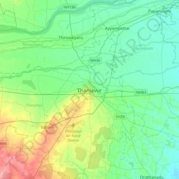
Name: Topografische Karte Thanjavur, Höhe, Relief.
Ort: Thanjavur, Thanjavur District, Tamil Nadu, 613001, India (10.62603 78.97815 10.94603 79.29815)
Durchschnittliche Höhe: 49 m
Minimale Höhe: 25 m
Maximale Höhe: 120 m
Thanjavur is located at 10°48′N 79°09′E / 10.8°N 79.15°E / 10.8; 79.15 The tributaries of river Cauvery, namely, the Grand Anaicut canal (Pudhaaru), Vadavaaru and Vennaaru rivers flow through the city. Thanjavur is situated in the Cauvery delta, at a distance of 314 km (195 mi) south-west of Chennai and 56 km (35 mi) east of Tiruchirappalli. While the plains immediately adjoining the Cauvery river have been under cultivation from time immemorial, most of Thanjavur city and the surrounding areas lie in the "New Delta" – a dry, barren upland tract which was brought under irrigation during the early 19th century. To the south of Thanjavur city, is the Vallam tableland, a small plateau interspersed at regular intervals by ridges of sandstone. The nearest seaport is Nagapattinam which is 84 km (52 mi) east of Thanjavur. The nearest airport is Tiruchirapalli International Airport, located at a distance of 56 km (35 mi). The city has an elevation of 59 m (194 ft) above mean sea level. The total area of the city is 36.33 km2 (14.03 sq mi).
Andere topografische Karten
Klicken Sie auf eine Karte, um ihre Topografie, ihre Höhe und ihr Relief anzuzeigen.
Pookkollai
India > Tamil Nadu > Thanjavur
Pookkollai, Thanjavur, Thanjavur District, Tamil Nadu, 208263, India
Durchschnittliche Höhe: 70 m
Valambakkudi
India > Tamil Nadu > Thanjavur
Valambakkudi, Thanjavur, Thanjavur District, Tamil Nadu, India
Durchschnittliche Höhe: 72 m
Budalur
India > Tamil Nadu > Thanjavur > Budalur
Budalur, Thanjavur, Thanjavur District, Tamil Nadu, 613602, India
Durchschnittliche Höhe: 55 m
Vallam
India > Tamil Nadu > Thanjavur > Vallam
Vallam, Thanjavur, Thanjavur District, Tamil Nadu, 613403, India
Durchschnittliche Höhe: 77 m