
Topografische Karte Srirangapatna
Interaktive Karte
Klicken Sie auf die Karte, um die Höhe anzuzeigen.
Über diese Karte
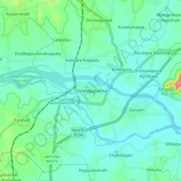
Name: Topografische Karte Srirangapatna, Höhe, Relief.
Durchschnittliche Höhe: 693 m
Minimale Höhe: 665 m
Maximale Höhe: 824 m
Srirangapatna is at 12°25′N 76°42′E / 12.41°N 76.7°E / 12.41; 76.7. It has an average elevation of 679 metres (2227 feet). Srirangapatna Sangama is the confluence of the three holy streams creating the island. Located 27 km upstream from the town is the spectacular Shivanasamudra Falls, the second biggest waterfall in India and the 16th largest in the world.
Andere topografische Karten
Klicken Sie auf eine Karte, um ihre Topografie, ihre Höhe und ihr Relief anzuzeigen.
Ganjam
India > Karnataka > Srirangapattana taluk > Ganjam
Ganjam, Srirangapattana taluk, Mandya district, Karnataka, 570020, India
Durchschnittliche Höhe: 684 m