
Topografische Karte Azeitão (São Lourenço e São Simão)
Interaktive Karte
Klicken Sie auf die Karte, um die Höhe anzuzeigen.
Über diese Karte
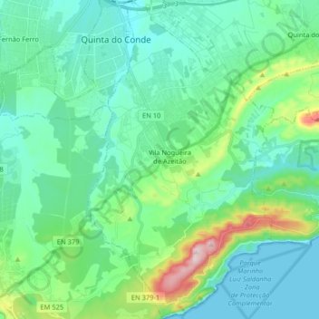
Name: Topografische Karte Azeitão (São Lourenço e São Simão), Höhe, Relief.
Ort: Azeitão (São Lourenço e São Simão), Setúbal, Portugal (38.45396 -9.05562 38.58072 -8.96108)
Durchschnittliche Höhe: 96 m
Minimale Höhe: 0 m
Maximale Höhe: 487 m
Andere topografische Karten
Klicken Sie auf eine Karte, um ihre Topografie, ihre Höhe und ihr Relief anzuzeigen.
Palácio e Quinta da Bacalhoa
Portugal > Setúbal > Setúbal > Vila Fresca de Azeitão
Durchschnittliche Höhe: 122 m
Aldeia de Irmãos
Portugal > Setúbal > Setúbal > Vila Nogueira de Azeitão
Durchschnittliche Höhe: 100 m