
Topografische Karte Vouzela
Interaktive Karte
Klicken Sie auf die Karte, um die Höhe anzuzeigen.
Über diese Karte
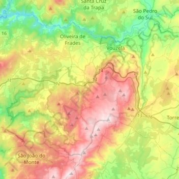
Name: Topografische Karte Vouzela, Höhe, Relief.
Ort: Vouzela, Viseu, Portugal (40.60062 -8.27428 40.75008 -8.00725)
Durchschnittliche Höhe: 478 m
Minimale Höhe: 61 m
Maximale Höhe: 1.052 m
Andere topografische Karten
Klicken Sie auf eine Karte, um ihre Topografie, ihre Höhe und ihr Relief anzuzeigen.
Germil
Portugal > Viseu > Penalva do Castelo
Germil, Penalva do Castelo, Viseu, Portugal
Durchschnittliche Höhe: 421 m
Cabaços
Portugal > Viseu > Moimenta da Beira
Cabaços, Moimenta da Beira, Viseu, Portugal
Durchschnittliche Höhe: 689 m
Lobão da Beira
Lobão da Beira, Tondela, Viseu, Portugal
Durchschnittliche Höhe: 280 m
Mezio
Portugal > Viseu > Castro Daire
Mezio, Castro Daire, Viseu, Portugal
Durchschnittliche Höhe: 969 m
Baldos
Portugal > Viseu > Moimenta da Beira
Baldos, Moimenta da Beira, Viseu, Portugal
Durchschnittliche Höhe: 647 m
São João da Pesqueira
São João da Pesqueira, Viseu, Portugal
Durchschnittliche Höhe: 528 m
Olas
Portugal > Viseu > São João da Pesqueira
Olas, São João da Pesqueira, Viseu, 5130-466, Portugal
Durchschnittliche Höhe: 410 m
Parada do Bispo
Parada do Bispo, Lamego, Viseu, 5100-650, Portugal
Durchschnittliche Höhe: 369 m