
Topografische Karte Hebden Bridge
Interaktive Karte
Klicken Sie auf die Karte, um die Höhe anzuzeigen.
Über diese Karte
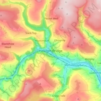
Name: Topografische Karte Hebden Bridge, Höhe, Relief.
Durchschnittliche Höhe: 277 m
Minimale Höhe: 85 m
Maximale Höhe: 447 m
Andere topografische Karten
Klicken Sie auf eine Karte, um ihre Topografie, ihre Höhe und ihr Relief anzuzeigen.
Todmorden
United Kingdom > England > Calderdale
Todmorden Town Hall, which was designed in the Neo-Classical style, dominates the centre of the town. The building straddles the Walsden Water, a tributary of the River Calder, and was situated in both Lancashire and Yorkshire until the administrative county boundary was moved on 1 January 1888. Designed by…
Durchschnittliche Höhe: 311 m
Norland Moor
United Kingdom > England > Calderdale > Norland > Norland Town
Durchschnittliche Höhe: 178 m
Todmorden
United Kingdom > England > Calderdale
Todmorden Town Hall, which was designed in the Neo-Classical style, dominates the centre of the town. The building straddles the Walsden Water, a tributary of the River Calder, and was situated in both Lancashire and Yorkshire until the administrative county boundary was moved on 1 January 1888. Designed by…
Durchschnittliche Höhe: 311 m
Ragby Plantation
United Kingdom > England > Calderdale > Todmorden > Walsden > Bottoms
Durchschnittliche Höhe: 293 m
Calder & Hebble Navigation Halifax Cut
United Kingdom > England > Calderdale > Skircoat Green
Durchschnittliche Höhe: 136 m
Gaddings Dam
United Kingdom > England > Calderdale > Todmorden > Walsden
Durchschnittliche Höhe: 282 m