Geolokalisieren

Topografische Karte Hebden Bridge

Interaktive Karte

Klicken Sie auf die Karte, um die Höhe anzuzeigen.

Über diese Karte

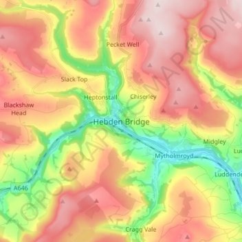
Name: Topografische Karte Hebden Bridge, Höhe, Relief.

Ort: Hebden Bridge, Calderdale, West Yorkshire, England, HX7 8AT, United Kingdom (53.70064 -2.04923 53.78064 -1.96923)

Durchschnittliche Höhe: 277 m

Minimale Höhe: 85 m

Maximale Höhe: 447 m

Andere topografische Karten

Klicken Sie auf eine Karte, um ihre Topografie, ihre Höhe und ihr Relief anzuzeigen.

Gaddings Dam

United Kingdom > England > Calderdale > Todmorden > Walsden

Gaddings Dam is a locally owned reservoir near to Todmorden in West Yorkshire, England. The dam was built to power water mills in the Todmorden area, being superseded by steam power and left redundant. It is notable for having a sandy beach at the north-eastern side which attracts people to it during the…

Durchschnittliche Höhe: 283 m

Todmorden

United Kingdom > England > Calderdale

Todmorden Town Hall, which was designed in the Neo-Classical style, dominates the centre of the town. The building straddles the Walsden Water, a tributary of the River Calder, and was situated in both Lancashire and Yorkshire until the administrative county boundary was moved on 1 January 1888. Designed by…

Durchschnittliche Höhe: 311 m

Norland Moor

United Kingdom > England > Calderdale > Norland > Norland Town

Durchschnittliche Höhe: 178 m

Todmorden

United Kingdom > England > Calderdale

Todmorden Town Hall, which was designed in the Neo-Classical style, dominates the centre of the town. The building straddles the Walsden Water, a tributary of the River Calder, and was situated in both Lancashire and Yorkshire until the administrative county boundary was moved on 1 January 1888. Designed by…

Durchschnittliche Höhe: 311 m

Ragby Plantation

United Kingdom > England > Calderdale > Todmorden > Walsden > Bottoms

Durchschnittliche Höhe: 293 m

Colden Water

United Kingdom > England > Calderdale > Heptonstall

Durchschnittliche Höhe: 226 m

Edge End Moor

United Kingdom > England > Calderdale > Mytholm

Durchschnittliche Höhe: 251 m

Heptonstall

United Kingdom > England > Calderdale

Durchschnittliche Höhe: 329 m

Ripponden

United Kingdom > England > Calderdale

Durchschnittliche Höhe: 285 m

Calder & Hebble Navigation

United Kingdom > England > Calderdale

Durchschnittliche Höhe: 95 m

Shibden Park

United Kingdom > England > Calderdale > Stump Cross

Durchschnittliche Höhe: 184 m

Todmorden

United Kingdom > England > Calderdale

Todmorden Town Hall, which was designed in the Neo-Classical style, dominates the centre of the town. The building straddles the Walsden Water, a tributary of the River Calder, and was situated in both Lancashire and Yorkshire until the administrative county boundary was moved on 1 January 1888. Designed by…

Durchschnittliche Höhe: 311 m

Gaddings Dam

United Kingdom > England > Calderdale > Todmorden > Walsden

Durchschnittliche Höhe: 282 m