
Topografische Karte Cartmel
Interaktive Karte
Klicken Sie auf die Karte, um die Höhe anzuzeigen.
Über diese Karte
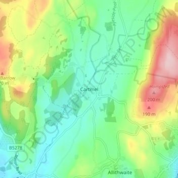
Name: Topografische Karte Cartmel, Höhe, Relief.
Durchschnittliche Höhe: 80 m
Minimale Höhe: 7 m
Maximale Höhe: 222 m
Andere topografische Karten
Klicken Sie auf eine Karte, um ihre Topografie, ihre Höhe und ihr Relief anzuzeigen.
Sharp Edge
United Kingdom > England > Westmorland and Furness > Mungrisdale
Durchschnittliche Höhe: 603 m
Goats Water
United Kingdom > England > Westmorland and Furness > Coniston
Durchschnittliche Höhe: 533 m
Barrow-in-Furness
United Kingdom > England > Westmorland and Furness > Biggar
Durchschnittliche Höhe: 22 m
Holmes Moss
United Kingdom > England > Westmorland and Furness > Garsdale
Durchschnittliche Höhe: 482 m
Brougham Castle
United Kingdom > England > Westmorland and Furness > Penrith
Durchschnittliche Höhe: 127 m
Wharton Tarn
United Kingdom > England > Westmorland and Furness > Hawkshead > Hawkshead Hill
Durchschnittliche Höhe: 173 m
Hard Tarn
United Kingdom > England > Westmorland and Furness > Patterdale
Durchschnittliche Höhe: 630 m
Newton Tarn
United Kingdom > England > Westmorland and Furness > High Newton > Low Newton
Durchschnittliche Höhe: 102 m
Brothers Water
United Kingdom > England > Westmorland and Furness > Patterdale > Hartsop
Durchschnittliche Höhe: 298 m
Levers Water
United Kingdom > England > Westmorland and Furness > Coniston
Durchschnittliche Höhe: 517 m
Priest Pot
United Kingdom > England > Westmorland and Furness > Colthouse
Durchschnittliche Höhe: 132 m
Brown Cove Tarn
United Kingdom > England > Westmorland and Furness > Patterdale
Durchschnittliche Höhe: 699 m
Alcock Tarn
United Kingdom > England > Westmorland and Furness > Grasmere
Durchschnittliche Höhe: 258 m
Three Dubs Tarn
United Kingdom > England > Westmorland and Furness > Bowness-on-Windermere
Durchschnittliche Höhe: 156 m
Jack Croft's Pond
United Kingdom > England > Westmorland and Furness > Newtown
Durchschnittliche Höhe: 217 m
School Knott Tarn
United Kingdom > England > Westmorland and Furness > Windermere
Durchschnittliche Höhe: 168 m
Knipe Tarn
United Kingdom > England > Westmorland and Furness > Winster > Mitchelland
Durchschnittliche Höhe: 131 m
Podnet Tarn
United Kingdom > England > Westmorland and Furness > Cartmel Fell
Durchschnittliche Höhe: 110 m
Cleabarrow Tarn
United Kingdom > England > Westmorland and Furness > Crook
Durchschnittliche Höhe: 161 m
Dovenest Wood
United Kingdom > England > Westmorland and Furness > Ambleside
Durchschnittliche Höhe: 134 m
Grisedale
United Kingdom > England > Westmorland and Furness > Glenridding
Durchschnittliche Höhe: 516 m
Howgill Fells
United Kingdom > England > Westmorland and Furness > Ravenstonedale
Durchschnittliche Höhe: 303 m
River Glenderamackin
United Kingdom > England > Westmorland and Furness > Threlkeld
Durchschnittliche Höhe: 346 m
Longsleddale
United Kingdom > England > Westmorland and Furness > Sadgill
Durchschnittliche Höhe: 339 m
Ullswater
United Kingdom > England > Westmorland and Furness > Glenridding
Durchschnittliche Höhe: 298 m
Mallerstang Edge
United Kingdom > England > Westmorland and Furness > Mallerstang
Durchschnittliche Höhe: 489 m
Trout Beck
United Kingdom > England > Westmorland and Furness > Troutbeck Bridge
Durchschnittliche Höhe: 308 m
Scout Scar
United Kingdom > England > Westmorland and Furness > Brigsteer
Scout Scar, also called Underbarrow Scar, is a hill in the English Lake District, west of Kendal, Cumbria and above the village of Underbarrow. It reaches 771 feet (235 m). Scout Scar is the subject of a chapter of Wainwright's book The Outlying Fells of Lakeland, but the summit he describes is a lower summit…
Durchschnittliche Höhe: 130 m
Roudsea Wood
United Kingdom > England > Westmorland and Furness > South Lakeland > Haverthwaite
Durchschnittliche Höhe: 7 m
Isle of Walney
United Kingdom > England > Westmorland and Furness > Biggar
Durchschnittliche Höhe: 10 m
Brougham
United Kingdom > England > Westmorland and Furness > Eamont Bridge
Durchschnittliche Höhe: 160 m
Deepdale Beck
United Kingdom > England > Westmorland and Furness > South Lakeland > Dent
Durchschnittliche Höhe: 280 m