
Topografische Karte Flash
Interaktive Karte
Klicken Sie auf die Karte, um die Höhe anzuzeigen.
Flash
Flash is a village in the Staffordshire Moorlands, England, and Peak District National Park. At 1,519 feet (463 m) above sea level, it is the highest village in the United Kingdom. Some sources claim a height of 1,531ft for Wanlockhead in Scotland, but a survey in 2019 showed that there are no buildings in Wanlockhead at that elevation. Flash was an early centre for Wesleyanism.
Über diese Karte
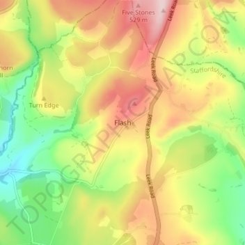
Name: Topografische Karte Flash, Höhe, Relief.
Durchschnittliche Höhe: 412 m
Minimale Höhe: 285 m
Maximale Höhe: 548 m
Andere topografische Karten
Klicken Sie auf eine Karte, um ihre Topografie, ihre Höhe und ihr Relief anzuzeigen.
Werrington
United Kingdom > England > Staffordshire > Staffordshire Moorlands
Durchschnittliche Höhe: 218 m
Alstonefield
United Kingdom > England > Staffordshire > Staffordshire Moorlands
Durchschnittliche Höhe: 279 m
Forsbrook
United Kingdom > England > Staffordshire > Staffordshire Moorlands
Durchschnittliche Höhe: 190 m
Onecote
United Kingdom > England > Staffordshire > Staffordshire Moorlands
Durchschnittliche Höhe: 309 m
Farley
United Kingdom > England > Staffordshire > Staffordshire Moorlands
Durchschnittliche Höhe: 221 m
Werrington
United Kingdom > England > Staffordshire > Staffordshire Moorlands
Durchschnittliche Höhe: 218 m
Cotton
United Kingdom > England > Staffordshire > Staffordshire Moorlands
Durchschnittliche Höhe: 272 m
Draycott in the Moors
United Kingdom > England > Staffordshire > Staffordshire Moorlands
Durchschnittliche Höhe: 177 m
Stepping Stones
United Kingdom > England > Staffordshire > Staffordshire Moorlands
Durchschnittliche Höhe: 224 m
Waterhouses
United Kingdom > England > Staffordshire > Staffordshire Moorlands
Durchschnittliche Höhe: 286 m
Rudyard Lake
United Kingdom > England > Staffordshire > Staffordshire Moorlands > Rudyard > Horton
Durchschnittliche Höhe: 205 m
Biddulph Grange Country Park
United Kingdom > England > Staffordshire > Staffordshire Moorlands > Biddulph > Biddulph Moor
Durchschnittliche Höhe: 229 m
Dilhorne
United Kingdom > England > Staffordshire > Staffordshire Moorlands
Durchschnittliche Höhe: 216 m
Hales Hall Pool
United Kingdom > England > Staffordshire > Staffordshire Moorlands > Cheadle
Durchschnittliche Höhe: 182 m
Cheadle
United Kingdom > England > Staffordshire > Staffordshire Moorlands
Durchschnittliche Höhe: 191 m
Grindon
United Kingdom > England > Staffordshire > Staffordshire Moorlands
Durchschnittliche Höhe: 287 m
Alton
United Kingdom > England > Staffordshire > Staffordshire Moorlands
Durchschnittliche Höhe: 156 m
Longnor
United Kingdom > England > Staffordshire > Staffordshire Moorlands
Durchschnittliche Höhe: 295 m
Cheddleton
United Kingdom > England > Staffordshire > Staffordshire Moorlands
Durchschnittliche Höhe: 204 m
Alstonefield
United Kingdom > England > Staffordshire > Staffordshire Moorlands
Durchschnittliche Höhe: 279 m
Farley
United Kingdom > England > Staffordshire > Staffordshire Moorlands
Durchschnittliche Höhe: 221 m
Ipstones
United Kingdom > England > Staffordshire > Staffordshire Moorlands
Durchschnittliche Höhe: 248 m
Consall
United Kingdom > England > Staffordshire > Staffordshire Moorlands > Consall
Durchschnittliche Höhe: 216 m
Biddulph
United Kingdom > England > Staffordshire > Staffordshire Moorlands
Durchschnittliche Höhe: 210 m
Hollinsclough
United Kingdom > England > Staffordshire > Staffordshire Moorlands
Durchschnittliche Höhe: 355 m
Wetton
United Kingdom > England > Staffordshire > Staffordshire Moorlands
Durchschnittliche Höhe: 274 m
Oakamoor
United Kingdom > England > Staffordshire > Staffordshire Moorlands
Durchschnittliche Höhe: 192 m
Bagnall
United Kingdom > England > Staffordshire > Staffordshire Moorlands > Bagnall
Durchschnittliche Höhe: 207 m
Kingsley
United Kingdom > England > Staffordshire > Staffordshire Moorlands
Durchschnittliche Höhe: 206 m
Heaton
United Kingdom > England > Staffordshire > Staffordshire Moorlands
Durchschnittliche Höhe: 234 m
Alton Castle
United Kingdom > England > Staffordshire > Staffordshire Moorlands > Alton
Durchschnittliche Höhe: 154 m
Caverswall
United Kingdom > England > Staffordshire > Staffordshire Moorlands
Durchschnittliche Höhe: 216 m