Geolokalisieren

Topografische Karte Cropwell Bishop

Interaktive Karte

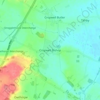
Klicken Sie auf die Karte, um die Höhe anzuzeigen.

Über diese Karte

Name: Topografische Karte Cropwell Bishop, Höhe, Relief.

Ort: Cropwell Bishop, Rushcliffe, Nottinghamshire, England, NG12 3DU, United Kingdom (52.89364 -1.00482 52.93364 -0.96482)

Durchschnittliche Höhe: 45 m

Minimale Höhe: 25 m

Maximale Höhe: 100 m

Andere topografische Karten

Klicken Sie auf eine Karte, um ihre Topografie, ihre Höhe und ihr Relief anzuzeigen.

Ratcliffe on Soar

United Kingdom > England > Nottinghamshire > Rushcliffe

Ratcliffe on Soar, Rushcliffe, Nottinghamshire, England, United Kingdom

Durchschnittliche Höhe: 36 m

Barton-in-Fabis

United Kingdom > England > Nottinghamshire > Rushcliffe

Barton-in-Fabis, Rushcliffe, Nottinghamshire, England, NG11 0AG, United Kingdom

Durchschnittliche Höhe: 37 m

West Bridgford

United Kingdom > England > Nottinghamshire > Rushcliffe

West Bridgford, Rushcliffe, Nottinghamshire, England, NG2 6BT, United Kingdom

Durchschnittliche Höhe: 39 m

Willoughby on the Wolds

United Kingdom > England > Nottinghamshire > Rushcliffe

Willoughby on the Wolds, Rushcliffe, Nottinghamshire, England, United Kingdom

Durchschnittliche Höhe: 92 m

Gotham

United Kingdom > England > Nottinghamshire > Rushcliffe

Gotham, Rushcliffe, Nottinghamshire, England, United Kingdom

Durchschnittliche Höhe: 49 m

Widmerpool

United Kingdom > England > Nottinghamshire > Rushcliffe

Widmerpool, Rushcliffe, Nottinghamshire, England, United Kingdom

Durchschnittliche Höhe: 77 m

Keyworth

United Kingdom > England > Nottinghamshire > Rushcliffe

Keyworth, Rushcliffe, Nottinghamshire, England, United Kingdom

Durchschnittliche Höhe: 68 m

Radcliffe on Trent

United Kingdom > England > Nottinghamshire > Rushcliffe

Radcliffe on Trent, Rushcliffe, Nottinghamshire, England, United Kingdom

Durchschnittliche Höhe: 37 m

Flintham

United Kingdom > England > Nottinghamshire > Rushcliffe

Flintham, Rushcliffe, Nottinghamshire, England, NG23 5LA, United Kingdom

Durchschnittliche Höhe: 35 m

West Bridgford

United Kingdom > England > Nottinghamshire > Rushcliffe

West Bridgford, Rushcliffe, Nottinghamshire, England, United Kingdom

Durchschnittliche Höhe: 36 m

Bassingfield

United Kingdom > England > Nottinghamshire > Rushcliffe > Holme Pierrepont > Bassingfield

Bassingfield, Holme Pierrepont, Rushcliffe, Nottinghamshire, England, NG12 2LH, United Kingdom

Durchschnittliche Höhe: 28 m

Ruddington

United Kingdom > England > Nottinghamshire > Rushcliffe

Ruddington, Rushcliffe, Nottinghamshire, England, United Kingdom

Durchschnittliche Höhe: 41 m

Newton

United Kingdom > England > Nottinghamshire > Rushcliffe

Newton, Rushcliffe, Nottinghamshire, East Midlands, England, United Kingdom

Durchschnittliche Höhe: 38 m

Orston

United Kingdom > England > Nottinghamshire > Rushcliffe > Orston

Orston, Rushcliffe, Nottinghamshire, East Midlands, England, United Kingdom

Durchschnittliche Höhe: 27 m

Wysall

United Kingdom > England > Nottinghamshire > Rushcliffe > Wysall

Wysall, Rushcliffe, Nottinghamshire, East Midlands, England, NG12 5QN, United Kingdom

Durchschnittliche Höhe: 73 m

Stanton on the Wolds

United Kingdom > England > Nottinghamshire > Rushcliffe > Stanton on the Wolds

Stanton on the Wolds, Rushcliffe, Nottinghamshire, East Midlands, England, NG12 5BL, United Kingdom

Durchschnittliche Höhe: 78 m

East Bridgford

United Kingdom > England > Nottinghamshire > Rushcliffe

East Bridgford, Rushcliffe, Nottinghamshire, England, United Kingdom

Durchschnittliche Höhe: 36 m

Stanford on Soar

United Kingdom > England > Nottinghamshire > Rushcliffe

Stanford on Soar, Rushcliffe, Nottinghamshire, England, United Kingdom

Durchschnittliche Höhe: 61 m

Colston Bassett

United Kingdom > England > Nottinghamshire > Rushcliffe > Colston Bassett

Colston Bassett, Rushcliffe, Nottinghamshire, East Midlands, England, United Kingdom

Durchschnittliche Höhe: 39 m

Bingham

United Kingdom > England > Nottinghamshire > Rushcliffe

Bingham, Rushcliffe, Nottinghamshire, England, United Kingdom

Durchschnittliche Höhe: 33 m

Aslockton

United Kingdom > England > Nottinghamshire > Rushcliffe

Aslockton, Rushcliffe, Nottinghamshire, England, NG13 9AT, United Kingdom

Durchschnittliche Höhe: 24 m

Zouch

United Kingdom > England > Nottinghamshire > Rushcliffe > Sutton Bonington

Zouch, Sutton Bonington, Rushcliffe, Nottinghamshire, England, LE12 5EQ, United Kingdom

Durchschnittliche Höhe: 49 m

West Leake

United Kingdom > England > Nottinghamshire > Rushcliffe > West Leake

West Leake, Rushcliffe, Nottinghamshire, East Midlands, England, United Kingdom

Durchschnittliche Höhe: 57 m

Sutton Bonington

United Kingdom > England > Nottinghamshire > Rushcliffe

Sutton Bonington, Rushcliffe, Nottinghamshire, England, United Kingdom

Durchschnittliche Höhe: 47 m

Holme Pierrepont

United Kingdom > England > Nottinghamshire > Rushcliffe

Holme Pierrepont, Rushcliffe, Nottinghamshire, England, United Kingdom

Durchschnittliche Höhe: 26 m

Kinoulton

United Kingdom > England > Nottinghamshire > Rushcliffe

Kinoulton, Rushcliffe, Nottinghamshire, England, United Kingdom

Durchschnittliche Höhe: 60 m

Bunny

United Kingdom > England > Nottinghamshire > Rushcliffe

Bunny, Rushcliffe, Nottinghamshire, England, United Kingdom

Durchschnittliche Höhe: 53 m