
Topografische Karte Sangli
Interaktive Karte
Klicken Sie auf die Karte, um die Höhe anzuzeigen.
Über diese Karte
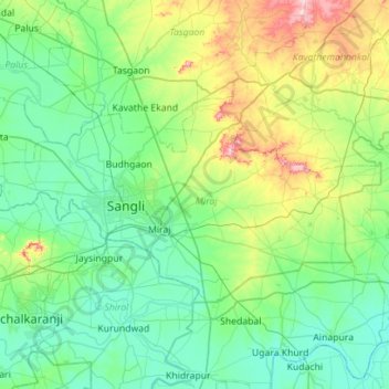
Name: Topografische Karte Sangli, Höhe, Relief.
Ort: Sangli, Sangli district, Maharashtra, India (16.71489 74.40159 17.01575 74.96313)
Durchschnittliche Höhe: 594 m
Minimale Höhe: 520 m
Maximale Höhe: 880 m
Andere topografische Karten
Klicken Sie auf eine Karte, um ihre Topografie, ihre Höhe und ihr Relief anzuzeigen.
Pimpri-Chinchwad
India > Maharashtra > Haveli
Pimpri-Chinchwad also known as "PCMC", is a city in the Indian state of Maharashtra. The city is about 15 km (9.3 mi) northwest of the historic city of Pune, at an altitude of 590 m (1,940 ft) above sea level. It is the fifth largest city in Maharashtra and the nineteenth largest city in India and the…
Durchschnittliche Höhe: 605 m
Goregaon
India > Maharashtra > Mangaon Taluka
Goregaon is located in the south-west of India at 18°10′N 73°18′E / 18.17°N 73.3°E / 18.17; 73.3. The average elevation is 28 metres (92 ft).
Durchschnittliche Höhe: 38 m
Trimbak
India > Maharashtra > Trimbakeshwar
Trimbak is located at 19°34′N 73°19′E / 19.56°N 73.32°E / 19.56; 73.32. It has an average elevation of 720 metres (2362 feet).
Durchschnittliche Höhe: 756 m
Shrivardhan Fort
India > Maharashtra > Mawal > Udhewadi > Vanati Kakurwardi
Durchschnittliche Höhe: 533 m
Pench (Indira Priyadarsini) National Park/Tiger Reserve
India > Maharashtra > Ramtek Taluka
Durchschnittliche Höhe: 485 m
Devagiri Fort
India > Maharashtra > Chhatrapati Sambhajinagar > Daulatabad
Durchschnittliche Höhe: 605 m