
Topografische Karte Épinal
Interaktive Karte
Klicken Sie auf die Karte, um die Höhe anzuzeigen.
Über diese Karte
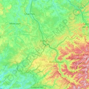
Name: Topografische Karte Épinal, Höhe, Relief.
Ort: Épinal, Vosges, Grand Est, France métropolitaine, France (47.81369 6.10152 48.47305 7.01621)
Durchschnittliche Höhe: 433 m
Minimale Höhe: 213 m
Maximale Höhe: 1.241 m
Andere topografische Karten
Klicken Sie auf eine Karte, um ihre Topografie, ihre Höhe und ihr Relief anzuzeigen.
Saut le Cerf
France > Grand Est > Vosges > Épinal
Saut le Cerf, Épinal, Vosges, Grand Est, France métropolitaine, 88000, France
Durchschnittliche Höhe: 349 m
Strasbourg
Strasbourg, Bas-Rhin, Grand Est, France métropolitaine, France
Durchschnittliche Höhe: 144 m
Nancy
France > Grand Est > Meurthe-et-Moselle
Nancy, Meurthe-et-Moselle, Grand Est, France métropolitaine, France
Durchschnittliche Höhe: 230 m
Deuxville
France > Grand Est > Meurthe-et-Moselle
Deuxville, Lunéville, Meurthe-et-Moselle, Grand Est, France métropolitaine, 54370, France
Durchschnittliche Höhe: 267 m
Aspach-le-Bas
France > Grand Est > Haut-Rhin
Aspach-le-Bas, Thann-Guebwiller, Haut-Rhin, Grand Est, France métropolitaine, 68700, France
Durchschnittliche Höhe: 306 m
Eckwersheim
Eckwersheim, Strasbourg, Bas-Rhin, Grand Est, France métropolitaine, 67550, France
Durchschnittliche Höhe: 156 m
Neufmoulins
Neufmoulins, Sarrebourg-Château-Salins, Moselle, Grand Est, France métropolitaine, 57830, France
Durchschnittliche Höhe: 290 m
Haute-Marne
Haute-Marne, Grand Est, France métropolitaine, France
Durchschnittliche Höhe: 308 m
Laudrefang
Laudrefang, Forbach-Boulay-Moselle, Moselle, Grand Est, France métropolitaine, 57385, France
Durchschnittliche Höhe: 352 m
Vireux
France > Grand Est > Ardennes > Vireux-Molhain
Vireux, Vireux-Molhain, Charleville-Mézières, Ardennes, Grand Est, France métropolitaine, 08320, France
Durchschnittliche Höhe: 149 m
Écrouves
France > Grand Est > Meurthe-et-Moselle
Écrouves, Toul, Meurthe-et-Moselle, Grand Est, France métropolitaine, 54200, France
Durchschnittliche Höhe: 271 m
Communauté d'agglomération Épernay, Coteaux et Plaine de Champagne
Communauté d'agglomération Épernay, Coteaux et Plaine de Champagne, Marne, Grand Est, France métropolitaine, France
Durchschnittliche Höhe: 142 m
Chauffourt
France > Grand Est > Haute-Marne
Chauffourt, Langres, Haute-Marne, Grand Est, France métropolitaine, 52140, France
Durchschnittliche Höhe: 423 m
Thionville
Thionville, Moselle, Grand Est, France métropolitaine, 57100, France
Durchschnittliche Höhe: 190 m
Hattonville
France > Grand Est > Meuse > Vigneulles-lès-Hattonchâtel
Hattonville, Vigneulles-lès-Hattonchâtel, Commercy, Meuse, Grand Est, France métropolitaine, 55210, France
Durchschnittliche Höhe: 238 m
Bertrichamps
France > Grand Est > Meurthe-et-Moselle
Bertrichamps, Lunéville, Meurthe-et-Moselle, Grand Est, France métropolitaine, 54120, France
Durchschnittliche Höhe: 322 m
Cosnes-et-Romain
France > Grand Est > Meurthe-et-Moselle
Cosnes-et-Romain, Val-de-Briey, Meurthe-et-Moselle, Grand Est, France métropolitaine, 54400, France
Durchschnittliche Höhe: 334 m
Kaysersberg-Vignoble
France > Grand Est > Haut-Rhin
Kaysersberg-Vignoble, Colmar-Ribeauvillé, Haut-Rhin, Grand Est, France métropolitaine, 68240, France
Durchschnittliche Höhe: 503 m
Saint-Just-Sauvage
Saint-Just-Sauvage, Épernay, Marne, Grand Est, France métropolitaine, 51260, France
Durchschnittliche Höhe: 74 m
Wettolsheim
France > Grand Est > Haut-Rhin
Wettolsheim, Colmar-Ribeauvillé, Haut-Rhin, Grand Est, France métropolitaine, 68920, France
Durchschnittliche Höhe: 293 m
Saint-Dié-des-Vosges
Saint-Dié-des-Vosges, Vosges, Grand Est, France métropolitaine, 88100, France
Durchschnittliche Höhe: 433 m
Frécourt
France > Grand Est > Haute-Marne
Frécourt, Langres, Haute-Marne, Grand Est, France métropolitaine, 52360, France
Durchschnittliche Höhe: 418 m
Thonne-la-Long
Thonne-la-Long, Verdun, Meuse, Grand Est, France métropolitaine, 55600, France
Durchschnittliche Höhe: 261 m
Bar-le-Duc
Bar-le-Duc, Meuse, Grand Est, France métropolitaine, 55000, France
Durchschnittliche Höhe: 253 m
Ugny
France > Grand Est > Meurthe-et-Moselle
Ugny, Val-de-Briey, Meurthe-et-Moselle, Grand Est, France métropolitaine, 54870, France
Durchschnittliche Höhe: 306 m
Pargny-sous-Mureau
Pargny-sous-Mureau, Neufchâteau, Vosges, Grand Est, France métropolitaine, 88350, France
Durchschnittliche Höhe: 358 m