
Topografische Karte Tirunelveli
Interaktive Karte
Klicken Sie auf die Karte, um die Höhe anzuzeigen.
Über diese Karte
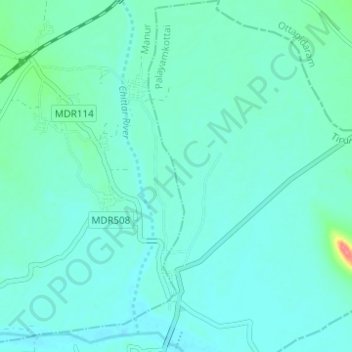
Name: Topografische Karte Tirunelveli, Höhe, Relief.
Durchschnittliche Höhe: 34 m
Minimale Höhe: 24 m
Maximale Höhe: 91 m
Tirunelveli is located at 8°43′41.82″N 77°41′43.94″E / 8.7282833°N 77.6955389°E / 8.7282833; 77.6955389, and its average elevation is 47 metres (154 ft). It is located at the southernmost tip of the Deccan plateau. The Tamirabarani River divides the city into the Tirunelveli quarter and the Palayamkottai area. The river (with its tributaries, such as the Chittar) is the major source of irrigation, and is fed by the northeast and southwest monsoons. The major lakes in the city are Nainar Lake and Udayarpetti Lake. The area around the Tamirabarani River and the Chittar has five streams: Kodagan, Palayan, Tirunelveli, Marudur East and Marudur West, and the Chittar feeds fifteen other channels. The soil is friable, red and sandy.
Andere topografische Karten
Klicken Sie auf eine Karte, um ihre Topografie, ihre Höhe und ihr Relief anzuzeigen.
Thamirabharani
India > Tamil Nadu > Tirunelveli
Thamirabharani, Tirunelveli, Tirunelveli District, Tamil Nadu, 627001, India
Durchschnittliche Höhe: 35 m
Tirunelveli
India > Tamil Nadu > Tirunelveli
Tirunelveli, Tirunelveli Kattabo, Tamil Nadu, India
Durchschnittliche Höhe: 65 m