
Topografische Karte East Hampshire
Interaktive Karte
Klicken Sie auf die Karte, um die Höhe anzuzeigen.
Über diese Karte
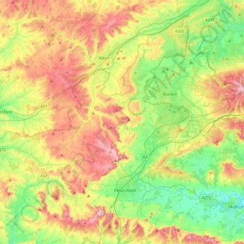
Name: Topografische Karte East Hampshire, Höhe, Relief.
Ort: East Hampshire, Hampshire, England, United Kingdom (50.94272 -1.13182 51.21274 -0.74470)
Durchschnittliche Höhe: 122 m
Minimale Höhe: 17 m
Maximale Höhe: 269 m
Andere topografische Karten
Klicken Sie auf eine Karte, um ihre Topografie, ihre Höhe und ihr Relief anzuzeigen.
Portsmouth
United Kingdom > England > Hampshire > Portsmouth
By road, Portsmouth lies 73.5 miles (118.3 km) from Central London, 49.5 miles (79.7 km) west of Brighton, and 22.3 miles (35.9 km) east of Southampton. Portsmouth is situated primarily on Portsea Island and is the United Kingdom's only island city, although parts of it have expanded onto the mainland. Gosport…
Durchschnittliche Höhe: 28 m
Basingstoke
United Kingdom > England > Hampshire > Basingstoke and Deane
Situated in a valley through the Hampshire Downs at an average elevation of 88 metres (289 ft) Basingstoke is a major interchange between Reading, Newbury, Andover, Winchester, and Alton, and lies on the natural trade route between the southwest of England and London. The area had been something of an…
Durchschnittliche Höhe: 110 m
Wolverton Townsend
United Kingdom > England > Hampshire > Basingstoke and Deane
Durchschnittliche Höhe: 106 m
Bath Meadows
United Kingdom > England > Hampshire > Test Valley > Wellow > East Wellow
Durchschnittliche Höhe: 30 m
Farnborough
United Kingdom > England > Hampshire > Rushmoor
Farnborough is located in the northeastern corner of the county of Hampshire, near the border with Surrey. The town occupies a valley setting, with the main urban area situated between the River Blackwater to the east and higher ground to the west. The topography gradually rises from the valley floor, reaching…
Durchschnittliche Höhe: 82 m
New Copse
United Kingdom > England > Hampshire > East Hampshire > Bentworth
Durchschnittliche Höhe: 184 m
Ditcham Woods.
United Kingdom > England > Hampshire > East Hampshire > Buriton
Durchschnittliche Höhe: 136 m
Pamber Green
United Kingdom > England > Hampshire > Basingstoke and Deane > Tadley
Durchschnittliche Höhe: 85 m
Mapledurwell
United Kingdom > England > Hampshire > Basingstoke and Deane
Durchschnittliche Höhe: 94 m
Brickkiln Copse
United Kingdom > England > Hampshire > Hart > Hound Green
Durchschnittliche Höhe: 61 m
Farnborough
United Kingdom > England > Hampshire > Rushmoor
Farnborough is located in the northeastern corner of the county of Hampshire, near the border with Surrey. The town occupies a valley setting, with the main urban area situated between the River Blackwater to the east and higher ground to the west. The topography gradually rises from the valley floor, reaching…
Durchschnittliche Höhe: 82 m
Wolverton Common
United Kingdom > England > Hampshire > Basingstoke and Deane
Durchschnittliche Höhe: 99 m
Basingstoke
United Kingdom > England > Hampshire > Basingstoke and Deane
Situated in a valley through the Hampshire Downs at an average elevation of 88 metres (289 ft) Basingstoke is a major interchange between Reading, Newbury, Andover, Winchester, and Alton, and lies on the natural trade route between the southwest of England and London. The area had been something of an…
Durchschnittliche Höhe: 107 m
Cold Ash Hill
United Kingdom > England > Hampshire > East Hampshire > Bramshott
Durchschnittliche Höhe: 126 m
News Wood
United Kingdom > England > Hampshire > Test Valley > King's Somborne
Durchschnittliche Höhe: 93 m
Anthill Common
United Kingdom > England > Hampshire > Winchester > Denmead
Durchschnittliche Höhe: 55 m
Sherborne St John
United Kingdom > England > Hampshire > Basingstoke and Deane
Durchschnittliche Höhe: 92 m
Drayton
United Kingdom > England > Hampshire > Test Valley > Barton Stacey
Durchschnittliche Höhe: 61 m
Morgaston Wood
United Kingdom > England > Hampshire > Basingstoke and Deane > Sherborne St John
Durchschnittliche Höhe: 76 m
Dunbridge
United Kingdom > England > Hampshire > Test Valley > Mottisfont
Durchschnittliche Höhe: 43 m
East Oakley
United Kingdom > England > Hampshire > Basingstoke and Deane
Durchschnittliche Höhe: 125 m
Fullerton
United Kingdom > England > Hampshire > Test Valley > Chilbolton
Durchschnittliche Höhe: 64 m
Withering Corner
United Kingdom > England > Hampshire > Test Valley > Ashley
Durchschnittliche Höhe: 120 m
Windabout Copse
United Kingdom > England > Hampshire > Basingstoke and Deane
Durchschnittliche Höhe: 80 m
Rowland's Copse, Red Hill
United Kingdom > England > Hampshire > East Hampshire > Rowlands Castle
Durchschnittliche Höhe: 42 m
Liphook
United Kingdom > England > Hampshire > East Hampshire
In Samuel Lewis's 1831 Topographical Dictionary of England, he referred to Liphook as a hamlet in the parish of Bramshott.
Durchschnittliche Höhe: 121 m
Ludshott Common
United Kingdom > England > Hampshire > East Hampshire > Bramshott
Durchschnittliche Höhe: 162 m
Havant Thicket
United Kingdom > England > Hampshire > East Hampshire > Rowlands Castle
Durchschnittliche Höhe: 48 m
Ashford Hill
United Kingdom > England > Hampshire > Basingstoke and Deane
Durchschnittliche Höhe: 88 m
Bramley Corner
United Kingdom > England > Hampshire > Basingstoke and Deane > Bramley
Durchschnittliche Höhe: 69 m
Blendworth
United Kingdom > England > Hampshire > East Hampshire > Horndean
Durchschnittliche Höhe: 86 m
Bighton Wood
United Kingdom > England > Hampshire > Winchester > Bighton
Durchschnittliche Höhe: 135 m