
Topografische Karte Lake Harris
Interaktive Karte
Klicken Sie auf die Karte, um die Höhe anzuzeigen.
Lake Harris
Lake Harris' depth is much greater than Lake Okeechobee to the south, with many deeper holes and ledges. The lake is surrounded by sandhills and cypress trees, part of the Central Florida Ridge. This region has the highest elevations in central Florida, reaching 312 feet (95 m) above sea level. Compared to the rest of Florida, which is relatively flat, it is quite hilly.
Über diese Karte
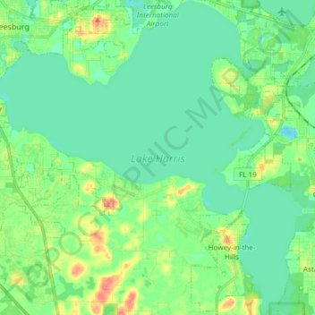
Name: Topografische Karte Lake Harris, Höhe, Relief.
Durchschnittliche Höhe: 25 m
Minimale Höhe: 11 m
Maximale Höhe: 59 m