
Topografische Karte Dangar Island
Interaktive Karte
Klicken Sie auf die Karte, um die Höhe anzuzeigen.
Über diese Karte
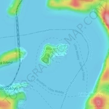
Name: Topografische Karte Dangar Island, Höhe, Relief.
Durchschnittliche Höhe: 17 m
Minimale Höhe: -3 m
Maximale Höhe: 153 m
Andere topografische Karten
Klicken Sie auf eine Karte, um ihre Topografie, ihre Höhe und ihr Relief anzuzeigen.
Hornby Lighthouse
The wing for staff quarters in an "I" plan with enclosed verandahs either side. This building probably c. 1850s building having very good ashlar work to external walls with each elevation recessed within a frame of foundation, eaves and quoin mouldings. Windows are marked by simple classical sill and lintel…
Durchschnittliche Höhe: 2 m