
Topografische Karte Rothley Brook
Interaktive Karte
Klicken Sie auf die Karte, um die Höhe anzuzeigen.
Über diese Karte
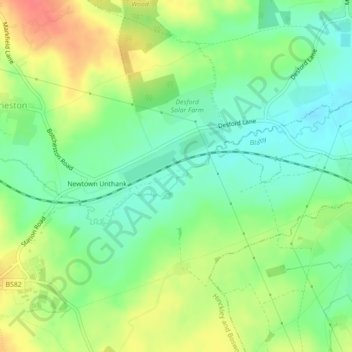
Name: Topografische Karte Rothley Brook, Höhe, Relief.
Durchschnittliche Höhe: 99 m
Minimale Höhe: 75 m
Maximale Höhe: 133 m
Andere topografische Karten
Klicken Sie auf eine Karte, um ihre Topografie, ihre Höhe und ihr Relief anzuzeigen.
Ratby
United Kingdom > England > Hinckley and Bosworth
Ratby, Hinckley and Bosworth, Leicestershire, East Midlands, England, United Kingdom
Durchschnittliche Höhe: 118 m
Barwell
United Kingdom > England > Hinckley and Bosworth > Barwell
Barwell, Hinckley and Bosworth, Leicestershire, East Midlands, England, LE9 8DD, United Kingdom
Durchschnittliche Höhe: 111 m
Bagworth & Thornton
United Kingdom > England > Hinckley and Bosworth
Bagworth & Thornton, Hinckley and Bosworth, Leicestershire, East Midlands, England, United Kingdom
Durchschnittliche Höhe: 140 m
Peckleton
United Kingdom > England > Hinckley and Bosworth
Peckleton, Hinckley and Bosworth, Leicestershire, East Midlands, England, United Kingdom
Durchschnittliche Höhe: 113 m
Tweed River
United Kingdom > England > Hinckley and Bosworth
Tweed River, Hinckley and Bosworth, Leicestershire, East Midlands, England, CV13 6DS, United Kingdom
Durchschnittliche Höhe: 98 m