
Topografische Karte Grouse Mountain
Interaktive Karte
Klicken Sie auf die Karte, um die Höhe anzuzeigen.
Grouse Mountain
Grouse Mountain is one of the North Shore Mountains of the Pacific Ranges in the District Municipality of North Vancouver, British Columbia, Canada. With a maximum elevation of over 1,200 m (4,100 feet) at its peak, the mountain is the site of an alpine ski area, Grouse Mountain Resort, which overlooks Greater Vancouver has four chairlifts servicing 33 runs. In the summer, Grouse Mountain Resort features lumberjack shows, the "Birds in Motion" birds of prey demonstration, a scenic chairlift ride, disc golf, mountain biking, zip lining, tandem paragliding, helicopter tours, and guided ecowalks. Year-round operations include a 100-seat mountaintop theatre and a wildlife refuge. The mountain operates two aerial tramways, known officially as the Skyride. The Blue Skyride is used mainly for freight transportation, while public access to the mountain top is provided by the Swiss-built Garaventa Red Skyride, which has a maximum capacity of 101 passengers (96 in summer). Summer access is also provided by the 2.9 kilometre Grouse Grind hiking trail, which is open for hiking from May to October.
Über diese Karte
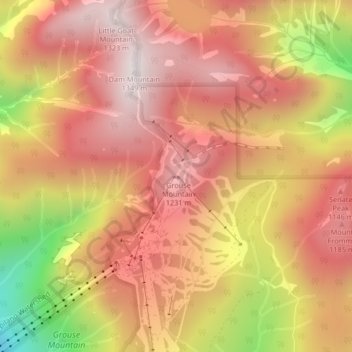
Name: Topografische Karte Grouse Mountain, Höhe, Relief.
Durchschnittliche Höhe: 968 m
Minimale Höhe: 358 m
Maximale Höhe: 1.313 m
Andere topografische Karten
Klicken Sie auf eine Karte, um ihre Topografie, ihre Höhe und ihr Relief anzuzeigen.
Vancouver
Canada > British Columbia > Metro Vancouver Regional District
Vancouver, British Columbia, is situated on the Burrard Peninsula, bordered by Burrard Inlet to the north and the Fraser River to the south. The city's topography is a blend of flat and hilly terrains, with elevations ranging from sea level to approximately 152 meters (500 feet) above sea level. The North…
Durchschnittliche Höhe: 34 m
Coquitlam
Canada > British Columbia > Metro Vancouver Regional District
Like much of Metro Vancouver, Coquitlam has an oceanic climate (Köppen climate type Cfb), experiencing mild temperatures and high precipitation; warm, dry summers and cool, wet winters. However, compared to most other cities in the area, precipitation is especially heavy in Coquitlam due to its proximity to…
Durchschnittliche Höhe: 190 m
Burnaby
Canada > British Columbia > Metro Vancouver Regional District
Burnaby occupies 98.6 square kilometres (38.1 sq mi) and is located at the geographic centre of the Metro Vancouver Regional District. The regional district's government is located in Burnaby's Metrotown area. Situated between the city of Vancouver on the west and Port Moody, Coquitlam, and New Westminster on…
Durchschnittliche Höhe: 59 m
Township of Langley
Canada > British Columbia > Metro Vancouver Regional District
Durchschnittliche Höhe: 47 m
Stanley Park
Canada > British Columbia > Metro Vancouver Regional District > Vancouver
Durchschnittliche Höhe: 14 m
Vancouver
Canada > British Columbia > Metro Vancouver Regional District
Vancouver, British Columbia, is situated on the Burrard Peninsula, bordered by Burrard Inlet to the north and the Fraser River to the south. The city's topography is a blend of flat and hilly terrains, with elevations ranging from sea level to approximately 152 meters (500 feet) above sea level. The North…
Durchschnittliche Höhe: 34 m
Lighthouse Park
Canada > British Columbia > Metro Vancouver Regional District > West Vancouver
The sword fern (Polystichum munitum), one of the most abundant ferns in North America, can be found from Alaska to California and is named for its small upward-pointing lobe that resembles a sword hilt. This fern prefers to grow in moist, coniferous low elevation environments but can survive dry periods.…
Durchschnittliche Höhe: 22 m
New Westminster
Canada > British Columbia > Metro Vancouver Regional District
Durchschnittliche Höhe: 44 m
Port Coquitlam
Canada > British Columbia > Metro Vancouver Regional District
Durchschnittliche Höhe: 29 m
West Vancouver
Canada > British Columbia > Metro Vancouver Regional District
Durchschnittliche Höhe: 384 m
Maple Ridge
Canada > British Columbia > Metro Vancouver Regional District
Durchschnittliche Höhe: 185 m
West Vancouver
Canada > British Columbia > Metro Vancouver Regional District
Durchschnittliche Höhe: 384 m
Coquitlam
Canada > British Columbia > Metro Vancouver Regional District
Like much of Metro Vancouver, Coquitlam has an oceanic climate (Köppen climate type Cfb), experiencing mild temperatures and high precipitation; warm, dry summers and cool, wet winters. However, compared to most other cities in the area, precipitation is especially heavy in Coquitlam due to its proximity to…
Durchschnittliche Höhe: 190 m
Tsawwassen
Canada > British Columbia > Metro Vancouver Regional District > Delta
Durchschnittliche Höhe: 12 m
Port Moody
Canada > British Columbia > Metro Vancouver Regional District
Durchschnittliche Höhe: 189 m
Pitt Meadows
Canada > British Columbia > Metro Vancouver Regional District
Durchschnittliche Höhe: 121 m
Vancouver
Canada > British Columbia > Metro Vancouver Regional District
Vancouver, British Columbia, is situated on the Burrard Peninsula, bordered by Burrard Inlet to the north and the Fraser River to the south. The city's topography is a blend of flat and hilly terrains, with elevations ranging from sea level to approximately 152 meters (500 feet) above sea level. The North…
Durchschnittliche Höhe: 34 m
West Cambie
Canada > British Columbia > Metro Vancouver Regional District > Richmond
Durchschnittliche Höhe: 3 m
Fairview
Canada > British Columbia > Metro Vancouver Regional District > Vancouver
Durchschnittliche Höhe: 31 m
Vancouver
Canada > British Columbia > Metro Vancouver Regional District
Vancouver's growing season averages 237 days, from March 18 until November 10. Vancouver's 1981–2010 USDA Plant Hardiness Zone ranges from 8a to 9a depending on elevation and proximity to water.
Durchschnittliche Höhe: 34 m
University Endowment Lands
Canada > British Columbia > Metro Vancouver Regional District
Snowfalls are also more common than many parts of the City of Vancouver because of the area's higher altitude and the lack of an urban heat island due to less terrestrial development.
Durchschnittliche Höhe: 58 m
Bowen Island
Canada > British Columbia > Metro Vancouver Regional District > Bowen Island Municipality
Durchschnittliche Höhe: 106 m
City of Langley
Canada > British Columbia > Metro Vancouver Regional District
Durchschnittliche Höhe: 19 m
Vancouver
Canada > British Columbia > Metro Vancouver Regional District
Vancouver's growing season averages 237 days, from March 18 until November 10. Vancouver's 1981–2010 USDA Plant Hardiness Zone ranges from 8a to 9a depending on elevation and proximity to water.
Durchschnittliche Höhe: 34 m
Vancouver East
Canada > British Columbia > Metro Vancouver Regional District > Vancouver
Durchschnittliche Höhe: 25 m
Ladner
Canada > British Columbia > Metro Vancouver Regional District > Delta
Durchschnittliche Höhe: 2 m
Kitsilano
Canada > British Columbia > Metro Vancouver Regional District > Vancouver
Durchschnittliche Höhe: 24 m
Barge Park
Canada > British Columbia > Metro Vancouver Regional District > White Rock
Durchschnittliche Höhe: 53 m
Township of Langley
Canada > British Columbia > Metro Vancouver Regional District
Durchschnittliche Höhe: 47 m
District of North Vancouver
Canada > British Columbia > Metro Vancouver Regional District
Durchschnittliche Höhe: 358 m
Aldergrove
Canada > British Columbia > Metro Vancouver Regional District > Township of Langley
Durchschnittliche Höhe: 107 m
Burnaby Lake Regional Park
Canada > British Columbia > Metro Vancouver Regional District > Burnaby
Durchschnittliche Höhe: 51 m
Cloverdale
Canada > British Columbia > Metro Vancouver Regional District > Surrey
Durchschnittliche Höhe: 24 m
Coquitlam
Canada > British Columbia > Metro Vancouver Regional District
Like much of Metro Vancouver, Coquitlam has an oceanic climate (Köppen climate type Cfb), experiencing mild temperatures and high precipitation; warm, dry summers and cool, wet winters. However, compared to most other cities in the area, precipitation is especially heavy in Coquitlam due to its proximity to…
Durchschnittliche Höhe: 190 m
Cougar Creek Park
Canada > British Columbia > Metro Vancouver Regional District > Surrey
Durchschnittliche Höhe: 86 m
West Vancouver
Canada > British Columbia > Metro Vancouver Regional District
Durchschnittliche Höhe: 384 m
West Vancouver
Canada > British Columbia > Metro Vancouver Regional District
Durchschnittliche Höhe: 384 m
Coquitlam
Canada > British Columbia > Metro Vancouver Regional District
Like much of Metro Vancouver, Coquitlam has an oceanic climate (Köppen climate type Cfb), experiencing mild temperatures and high precipitation; warm, dry summers and cool, wet winters. However, compared to most other cities in the area, precipitation is especially heavy in Coquitlam due to its proximity to…
Durchschnittliche Höhe: 190 m
Tynehead Regional Park
Canada > British Columbia > Metro Vancouver Regional District > Surrey
Durchschnittliche Höhe: 45 m
Burnaby
Canada > British Columbia > Metro Vancouver Regional District
Burnaby occupies 96.6 square kilometres (37.3 sq mi) and is located at the geographic centre of the Metro Vancouver Regional District. The city has four areas of urban density known as "town centres": Lougheed, Edmonds, Metrotown, and Brentwood. The city's governmental and cultural precincts are located in…
Durchschnittliche Höhe: 59 m
Cleveland Dam
Canada > British Columbia > Metro Vancouver Regional District
Durchschnittliche Höhe: 205 m
Tower Beach
Canada > British Columbia > Metro Vancouver Regional District > Electoral Area A
Durchschnittliche Höhe: 27 m
Green Timbers Urban Forest
Canada > British Columbia > Metro Vancouver Regional District > Surrey
Durchschnittliche Höhe: 100 m
Wreck Beach
Canada > British Columbia > Metro Vancouver Regional District > Electoral Area A
Durchschnittliche Höhe: 32 m
Steveston
Canada > British Columbia > Metro Vancouver Regional District > Richmond
Durchschnittliche Höhe: 2 m
Tsawwassen
Canada > British Columbia > Metro Vancouver Regional District > Delta
Durchschnittliche Höhe: 12 m
Burnaby
Canada > British Columbia > Metro Vancouver Regional District
Burnaby occupies 96.6 square kilometres (37.3 sq mi) and is located at the geographic centre of the Metro Vancouver Regional District. The city has four areas of urban density known as "town centres": Lougheed, Edmonds, Metrotown, and Brentwood. The city's governmental and cultural precincts are located in…
Durchschnittliche Höhe: 59 m
Ladner
Canada > British Columbia > Metro Vancouver Regional District > Delta
Durchschnittliche Höhe: 2 m
Granville Island
Canada > British Columbia > Metro Vancouver Regional District > Vancouver
Durchschnittliche Höhe: 25 m
Queen Elizabeth Park
Canada > British Columbia > Metro Vancouver Regional District > Vancouver
Durchschnittliche Höhe: 81 m
South Surrey
Canada > British Columbia > Metro Vancouver Regional District > Surrey
Durchschnittliche Höhe: 28 m
Annacis Island
Canada > British Columbia > Metro Vancouver Regional District > Delta
Durchschnittliche Höhe: 16 m
Barnes Lake
Canada > British Columbia > Metro Vancouver Regional District > Electoral Area A
Durchschnittliche Höhe: 1.277 m
Essondale Islet
Canada > British Columbia > Metro Vancouver Regional District > Port Coquitlam
Durchschnittliche Höhe: 12 m
Dunbar-Southlands
Canada > British Columbia > Metro Vancouver Regional District > Vancouver
Durchschnittliche Höhe: 43 m
Morgan Heights
Canada > British Columbia > Metro Vancouver Regional District > Surrey
Durchschnittliche Höhe: 61 m
Seymour River
Canada > British Columbia > Metro Vancouver Regional District > Electoral Area A
Durchschnittliche Höhe: 490 m
Deer Lake
Canada > British Columbia > Metro Vancouver Regional District > Burnaby
Durchschnittliche Höhe: 60 m
Surrey--Newton
Canada > British Columbia > Metro Vancouver Regional District > Surrey
Durchschnittliche Höhe: 71 m
Marpole
Canada > British Columbia > Metro Vancouver Regional District > Vancouver
Durchschnittliche Höhe: 28 m
Kensington Park
Canada > British Columbia > Metro Vancouver Regional District > Vancouver
Durchschnittliche Höhe: 81 m
Deer Lake Park
Canada > British Columbia > Metro Vancouver Regional District > Burnaby
Durchschnittliche Höhe: 64 m
Westminster Pier Park
Canada > British Columbia > Metro Vancouver Regional District > New Westminster
Durchschnittliche Höhe: 27 m
Jericho Beach
Canada > British Columbia > Metro Vancouver Regional District > Vancouver
Durchschnittliche Höhe: 20 m
Kerrisdale
Canada > British Columbia > Metro Vancouver Regional District > Vancouver
Durchschnittliche Höhe: 39 m
Tsawwassen Causeway Beach
Canada > British Columbia > Metro Vancouver Regional District > Delta
Durchschnittliche Höhe: 1 m
Yew Lake
Canada > British Columbia > Metro Vancouver Regional District > West Vancouver
Durchschnittliche Höhe: 990 m
Queen Elizabeth Park
Canada > British Columbia > Metro Vancouver Regional District > Vancouver
Durchschnittliche Höhe: 81 m
Surrey Lake
Canada > British Columbia > Metro Vancouver Regional District > Surrey
Durchschnittliche Höhe: 26 m
Coquitlam
Canada > British Columbia > Metro Vancouver Regional District
Like much of Metro Vancouver, Coquitlam has an oceanic climate (Köppen climate type Cfb), experiencing mild temperatures and high precipitation; warm, dry summers and cool, wet winters. However, compared to most other cities in the area, precipitation is especially heavy in Coquitlam due to its proximity to…
Durchschnittliche Höhe: 190 m
Woodlot 0007
Canada > British Columbia > Metro Vancouver Regional District > Maple Ridge
Durchschnittliche Höhe: 322 m
Vancouver
Canada > British Columbia > Metro Vancouver Regional District
Vancouver, British Columbia, is situated on the Burrard Peninsula, bordered by Burrard Inlet to the north and the Fraser River to the south. The city's topography is a blend of flat and hilly terrains, with elevations ranging from sea level to approximately 152 meters (500 feet) above sea level. The North…
Durchschnittliche Höhe: 34 m
Golden Ears Provincial Park
Canada > British Columbia > Metro Vancouver Regional District
Durchschnittliche Höhe: 794 m
Kitsilano
Canada > British Columbia > Metro Vancouver Regional District > Vancouver
Durchschnittliche Höhe: 24 m
Pitt Lake
Canada > British Columbia > Metro Vancouver Regional District > Electoral Area A
Durchschnittliche Höhe: 659 m
Newton Athletic Park
Canada > British Columbia > Metro Vancouver Regional District > Surrey
Durchschnittliche Höhe: 86 m
Livingstone Lake
Canada > British Columbia > Metro Vancouver Regional District > Vancouver
Durchschnittliche Höhe: 86 m
Maywood
Canada > British Columbia > Metro Vancouver Regional District > Burnaby
Durchschnittliche Höhe: 113 m
English Bay
Canada > British Columbia > Metro Vancouver Regional District > Vancouver
Durchschnittliche Höhe: 7 m
Crescent Beach
Canada > British Columbia > Metro Vancouver Regional District > Surrey
Durchschnittliche Höhe: 22 m
Buntzen Bay
Canada > British Columbia > Metro Vancouver Regional District > Anmore
Durchschnittliche Höhe: 214 m
North Vancouver
Canada > British Columbia > Metro Vancouver Regional District
Durchschnittliche Höhe: 54 m
Victoria-Fraserview
Canada > British Columbia > Metro Vancouver Regional District > Vancouver
Durchschnittliche Höhe: 67 m
Vancouver
Canada > British Columbia > Metro Vancouver Regional District
Vancouver, British Columbia, is situated on the Burrard Peninsula, bordered by Burrard Inlet to the north and the Fraser River to the south. The city's topography is a blend of flat and hilly terrains, with elevations ranging from sea level to approximately 152 meters (500 feet) above sea level. The North…
Durchschnittliche Höhe: 34 m
Finn Slough
Canada > British Columbia > Metro Vancouver Regional District > Richmond
Durchschnittliche Höhe: 2 m
False Creek
Canada > British Columbia > Metro Vancouver Regional District > Vancouver
Durchschnittliche Höhe: 18 m
Annacis Island
Canada > British Columbia > Metro Vancouver Regional District > Delta
Durchschnittliche Höhe: 16 m
Town Centre Park
Canada > British Columbia > Metro Vancouver Regional District > Coquitlam
Durchschnittliche Höhe: 62 m
Newton
Canada > British Columbia > Metro Vancouver Regional District > Surrey
Durchschnittliche Höhe: 48 m
Fort Langley
Canada > British Columbia > Metro Vancouver Regional District > Township of Langley
Durchschnittliche Höhe: 7 m
Burnaby Lake
Canada > British Columbia > Metro Vancouver Regional District > Burnaby
Durchschnittliche Höhe: 32 m