
Topografische Karte Pendle Hill
Interaktive Karte
Klicken Sie auf die Karte, um die Höhe anzuzeigen.
Über diese Karte
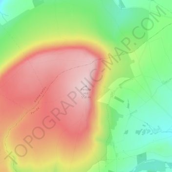
Name: Topografische Karte Pendle Hill, Höhe, Relief.
Durchschnittliche Höhe: 385 m
Minimale Höhe: 211 m
Maximale Höhe: 557 m
Andere topografische Karten
Klicken Sie auf eine Karte, um ihre Topografie, ihre Höhe und ihr Relief anzuzeigen.
Colne Water
United Kingdom > England > Lancashire > Borough of Pendle > Laneshaw Bridge
Durchschnittliche Höhe: 202 m
Barrowford
United Kingdom > England > Lancashire > Borough of Pendle > Barrowford
Durchschnittliche Höhe: 161 m
Barnoldswick
United Kingdom > England > Lancashire > Borough of Pendle > Salterforth
Durchschnittliche Höhe: 175 m
Colne
United Kingdom > England > Lancashire > Borough of Pendle
Pendle Leisure Trust runs the Pendle Leisure Centre next to the railway station. The facility has two swimming pools, a fitness centre and gymnasium, sauna and sports hall. In summer 2013, the outdoor all-weather pitch was replaced by Urban Altitude. This outdoor aerial assault course is the first of its kind…
Durchschnittliche Höhe: 197 m