
Topografische Karte Golfo San Matías
Interaktive Karte
Klicken Sie auf die Karte, um die Höhe anzuzeigen.
Über diese Karte
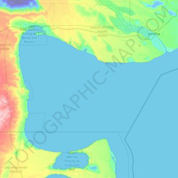
Name: Topografische Karte Golfo San Matías, Höhe, Relief.
Durchschnittliche Höhe: 34 m
Minimale Höhe: -72 m
Maximale Höhe: 383 m
Andere topografische Karten
Klicken Sie auf eine Karte, um ihre Topografie, ihre Höhe und ihr Relief anzuzeigen.
Bahía Creek
Argentina > Río Negro > Viedma > Bahía Creek
Bahía Creek, Viedma, Departamento Adolfo Alsina, Río Negro, R8501, Argentina
Durchschnittliche Höhe: 32 m
Sargento Cabral
Argentina > Río Negro > Viedma
Sargento Cabral, Viedma, Departamento Adolfo Alsina, Río Negro, Argentina
Durchschnittliche Höhe: 6 m
Laguna La Salina
Argentina > Río Negro > Viedma
Laguna La Salina, Ruta Provincial 51, Viedma, Departamento Adolfo Alsina, Río Negro, Argentina
Durchschnittliche Höhe: 10 m