Geolokalisieren

Topografische Karte Carlisle

Interaktive Karte

Klicken Sie auf die Karte, um die Höhe anzuzeigen.

Über diese Karte

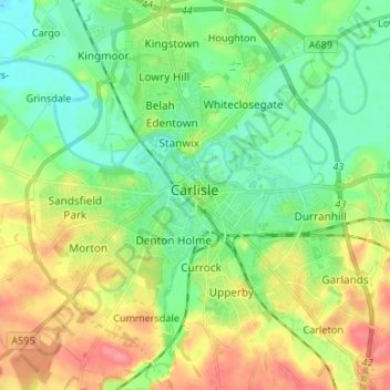
Name: Topografische Karte Carlisle, Höhe, Relief.

Ort: Carlisle, Cumberland, England, United Kingdom (54.85565 -2.98940 54.93207 -2.87749)

Durchschnittliche Höhe: 31 m

Minimale Höhe: 5 m

Maximale Höhe: 75 m

Andere topografische Karten

Klicken Sie auf eine Karte, um ihre Topografie, ihre Höhe und ihr Relief anzuzeigen.

Crosby-on-Eden

United Kingdom > England > Cumberland > Low Crosby > High Crosby

Durchschnittliche Höhe: 22 m

Crosby

United Kingdom > England > Cumberland

Durchschnittliche Höhe: 38 m

Keswick

United Kingdom > England > Cumberland

Durchschnittliche Höhe: 128 m

Keswick

United Kingdom > England > Cumberland

Durchschnittliche Höhe: 128 m

Black Combe

United Kingdom > England > Cumberland

Walks to the top of the fell begin at St Mary's Church, Whicham to the south; St Mary's Church, Whitbeck to the west or from the Corney Fell Road which crosses the fells at an altitude of 1,250 ft (380 m) 4 miles (6.4 km) to the north of the top. A more challenging and interesting route begins at Beckside Farm…

Durchschnittliche Höhe: 360 m

Cat Bells

United Kingdom > England > Cumberland > Stair

Durchschnittliche Höhe: 182 m

Scafell Pike

United Kingdom > England > Cumberland

Scafell Pike (/ˈskɔːfɛl paɪk/) is the highest and the most prominent mountain in England, at an elevation of 978 metres (3,209 ft) above sea level. It is located in the Lake District National Park, in Cumbria, and is part of the Southern Fells and the Scafell massif.

Durchschnittliche Höhe: 679 m

Whitbeck

United Kingdom > England > Cumberland

Durchschnittliche Höhe: 141 m

Longlands Fell

United Kingdom > England > Cumberland

Durchschnittliche Höhe: 361 m

Bowness

United Kingdom > England > Cumberland

Durchschnittliche Höhe: 8 m

Bakestall

United Kingdom > England > Cumberland

Durchschnittliche Höhe: 517 m

Harrington

United Kingdom > England > Cumberland > Workington

Durchschnittliche Höhe: 36 m

Seatallan

United Kingdom > England > Cumberland

Seatallan is a mountain in the western part of the English Lake District. It is rounded, grassy and fairly unassuming, occupying a large amount of land. However, it is classed as a Marilyn because of the low elevation of the col connecting it to Haycock, its nearest higher neighbour to the north. The name…

Durchschnittliche Höhe: 452 m

Hindscarth

United Kingdom > England > Cumberland

Durchschnittliche Höhe: 458 m

Great Cockup

United Kingdom > England > Cumberland

Durchschnittliche Höhe: 413 m

Wallowbarrow Crag

United Kingdom > England > Cumberland > Ulpha

Durchschnittliche Höhe: 212 m

Esk Pike

United Kingdom > England > Cumberland

To the north-west of Esk Pike is the depression of Esk Hause, a broad saddle carrying a number of important paths. The ‘true’ Esk Hause—so named by Alfred Wainwright in his influential Pictorial Guide to the Lakeland Fells—is the north–south route from Borrowdale to Eskdale. A lower path—the…

Durchschnittliche Höhe: 652 m

Muncaster Fell

United Kingdom > England > Cumberland

Durchschnittliche Höhe: 68 m

Kershopefoot

United Kingdom > England > Cumberland

Durchschnittliche Höhe: 157 m

Mellbreak

United Kingdom > England > Cumberland

Durchschnittliche Höhe: 224 m

Rannerdale Knotts

United Kingdom > England > Cumberland > Buttermere

The highest ground in the North Western Fells is an east-west ridge in this central sector, beginning with Grasmoor above Crummock Water and then gradually descending eastwards over Crag Hill, Sail, Scar Crags and Causey Pike. Grasmoor has the greatest elevation, but Crag Hill stands at the hub of the range.…

Durchschnittliche Höhe: 212 m

Buttermere

United Kingdom > England > Cumberland

Durchschnittliche Höhe: 346 m

Fellbarrow

United Kingdom > England > Cumberland

The two fells form a ridge 2 miles long with the lower Fellbarrow at the northern end. Alfred Wainwright in his influential Pictorial Guide to the Lakeland Fells was forced to estimate the elevation of Low Fell and considered (although with some doubts) Fellbarrow to be the high point of the ridge. There are a…

Durchschnittliche Höhe: 256 m

Ling Fell

United Kingdom > England > Cumberland

Ling Fell and Sale Fell, despite standing side by side, have no topographical connection. Ling Fell's 'parent' is Broom Fell, while Sale Fell is an outlier of Lord's Seat. They are separated by the stream of Wythop Beck which drains a catchment to the east. The two fells act as portals to this shy valley as it…

Durchschnittliche Höhe: 249 m

Ard Crags

United Kingdom > England > Cumberland

Ard Crags is a fell in the Lake District in Cumbria, England, it is situated in the Newlands Valley just off the minor road between Keswick and Buttermere. The Ordnance Survey officially records the fell's altitude at 581 metres (1,906 ft), considerably more than the approximate 1,860 feet (570 m) that Alfred…

Durchschnittliche Höhe: 420 m

Nova Scotia

United Kingdom > England > Cumberland

Durchschnittliche Höhe: 31 m

Little Corby

United Kingdom > England > Cumberland

Durchschnittliche Höhe: 35 m

Egremont

United Kingdom > England > Cumberland

Durchschnittliche Höhe: 91 m

Arnaby

United Kingdom > England > Cumberland > The Green

Durchschnittliche Höhe: 48 m

Cat Bells

United Kingdom > England > Cumberland > Stair

Durchschnittliche Höhe: 182 m

Calder Bridge

United Kingdom > England > Cumberland

Durchschnittliche Höhe: 75 m

Blennerhasset

United Kingdom > England > Cumberland

Durchschnittliche Höhe: 80 m

High Spy

United Kingdom > England > Cumberland

The fell reaches a height of 653 metres (2,142 feet) and is defended by crags to the east and west as it falls away steeply to the valleys. It is a distinctive fell that has 148 metres (486 feet) of topographic prominence from the higher adjoining fell of Dale Head and so misses being a Marilyn by only two…

Durchschnittliche Höhe: 404 m

Allonby

United Kingdom > England > Cumberland

Durchschnittliche Höhe: 7 m

Broughton Moor

United Kingdom > England > Cumberland

Durchschnittliche Höhe: 92 m

Buckabank

United Kingdom > England > Cumberland > Dalston

Durchschnittliche Höhe: 69 m

Scafell Pike

United Kingdom > England > Cumberland

Scafell Pike (/ˈskɔːfɛl paɪk/) is a mountain in the Lake District region of Cumbria, England. It has an elevation of 978 metres (3,209 ft) above sea level, making it the highest and the most prominent mountain in England. The mountain is part of the Scafell massif, an extinct volcano, and is one of the…

Durchschnittliche Höhe: 679 m

Longtown

United Kingdom > England > Cumberland

Durchschnittliche Höhe: 27 m

Boot

United Kingdom > England > Cumberland

Durchschnittliche Höhe: 181 m

Eskdale

United Kingdom > England > Cumberland

Durchschnittliche Höhe: 310 m

Grange

United Kingdom > England > Cumberland

Durchschnittliche Höhe: 265 m

Langrigg

United Kingdom > England > Cumberland

Durchschnittliche Höhe: 31 m

Old Windlebrowe

United Kingdom > England > Cumberland > Keswick

Durchschnittliche Höhe: 168 m

Upper Denton

United Kingdom > England > Cumberland

Durchschnittliche Höhe: 160 m

Talkin Fell

United Kingdom > England > Cumberland

Durchschnittliche Höhe: 281 m

Oughterside

United Kingdom > England > Cumberland

Durchschnittliche Höhe: 62 m

Seatoller

United Kingdom > England > Cumberland

Durchschnittliche Höhe: 317 m

Portinscale

United Kingdom > England > Cumberland

Durchschnittliche Höhe: 98 m

Hesket Newmarket

United Kingdom > England > Cumberland

Durchschnittliche Höhe: 218 m

Sail

United Kingdom > England > Cumberland > Buttermere

Durchschnittliche Höhe: 513 m

Hallbankgate

United Kingdom > England > Cumberland

Durchschnittliche Höhe: 213 m

Cardurnock

United Kingdom > England > Cumberland

Durchschnittliche Höhe: 4 m

High Tove

United Kingdom > England > Cumberland

Durchschnittliche Höhe: 428 m

Woodend Height

United Kingdom > England > Cumberland

Durchschnittliche Höhe: 335 m

Birkby Fell

United Kingdom > England > Cumberland

Durchschnittliche Höhe: 238 m

Setmurthy Common

United Kingdom > England > Cumberland > Embleton > Setmurthy

Durchschnittliche Höhe: 151 m

Wast Water

United Kingdom > England > Cumberland

Durchschnittliche Höhe: 239 m

Talkin

United Kingdom > England > Cumberland

Durchschnittliche Höhe: 173 m

Newby East

United Kingdom > England > Cumberland > Little Corby

Durchschnittliche Höhe: 32 m

High Rigg

United Kingdom > England > Cumberland

High Rigg is a small fell located in the English Lake District, approximately three miles southeast of the town of Keswick. It occupies an unusual position, surrounded on all sides by higher fells but not connected by any obvious ridge. This separation from its fellows ensures that it is a Marilyn (a hill with…

Durchschnittliche Höhe: 204 m

High Stile (Wainwright)

United Kingdom > England > Cumberland > Buttermere

Durchschnittliche Höhe: 435 m

Plumbland

United Kingdom > England > Cumberland

Durchschnittliche Höhe: 122 m

Stainburn

United Kingdom > England > Cumberland > Workington

Durchschnittliche Höhe: 49 m

Grey Crags

United Kingdom > England > Cumberland

Durchschnittliche Höhe: 509 m

Allen Crags

United Kingdom > England > Cumberland

Durchschnittliche Höhe: 626 m

Dale Head

United Kingdom > England > Cumberland > Buttermere

Durchschnittliche Höhe: 478 m

Great Gable

United Kingdom > England > Cumberland > Borrowdale

Durchschnittliche Höhe: 509 m

Glaramara

United Kingdom > England > Cumberland

Durchschnittliche Höhe: 478 m

Ullock

United Kingdom > England > Cumberland > Portinscale

Durchschnittliche Höhe: 120 m

Birkby

United Kingdom > England > Cumberland

Durchschnittliche Höhe: 39 m

Sandale

United Kingdom > England > Cumberland

Durchschnittliche Höhe: 206 m

The Hill

United Kingdom > England > Cumberland

Durchschnittliche Höhe: 35 m

Pillar

United Kingdom > England > Cumberland

Durchschnittliche Höhe: 486 m

Sale Fell

United Kingdom > England > Cumberland

Durchschnittliche Höhe: 189 m

Hardknott Pass

United Kingdom > England > Cumberland > Ulpha

The Hardknott Pass stands at a maximum elevation of 393 m (1,289 ft). The road descends steeply at a gradient of 30% (1 in 3) into the Duddon Valley. At the eastern end of the pass is Cockley Beck farm, built in the 1860s and owned by the National Trust. The route from Hardknott leads eastward towards the…

Durchschnittliche Höhe: 323 m

Low Melbecks

United Kingdom > England > Cumberland > Bassenthwaite

Durchschnittliche Höhe: 229 m

Hallthwaites

United Kingdom > England > Cumberland

Durchschnittliche Höhe: 76 m

Keswick

United Kingdom > England > Cumberland

Durchschnittliche Höhe: 128 m

Blencogo

United Kingdom > England > Cumberland

Durchschnittliche Höhe: 23 m

Rosthwaite

United Kingdom > England > Cumberland

Durchschnittliche Höhe: 274 m

Foulbog Rigg

United Kingdom > England > Cumberland

Durchschnittliche Höhe: 340 m

Tindale

United Kingdom > England > Cumberland > Farlam

Durchschnittliche Höhe: 244 m

Great Corby

United Kingdom > England > Cumberland

Durchschnittliche Höhe: 58 m

Derwentwater

United Kingdom > England > Cumberland > Grange

Durchschnittliche Höhe: 161 m

Frizington

United Kingdom > England > Cumberland

Durchschnittliche Höhe: 130 m

Armaside

United Kingdom > England > Cumberland > Lorton

Durchschnittliche Höhe: 121 m

Rottington

United Kingdom > England > Cumberland

Durchschnittliche Höhe: 56 m

Sandwith

United Kingdom > England > Cumberland > Whitehaven

Durchschnittliche Höhe: 58 m

Walla Crag

United Kingdom > England > Cumberland

Durchschnittliche Höhe: 228 m

Latrigg

United Kingdom > England > Cumberland > Uldale

Durchschnittliche Höhe: 228 m

Milton

United Kingdom > England > Cumberland > Brampton

Durchschnittliche Höhe: 139 m

Camerton

United Kingdom > England > Cumberland

Durchschnittliche Höhe: 65 m

Legburthwaite

United Kingdom > England > Cumberland

Durchschnittliche Höhe: 392 m

Whitehaven

United Kingdom > England > Cumberland

Durchschnittliche Höhe: 59 m

Roweltown

United Kingdom > England > Cumberland

Durchschnittliche Höhe: 108 m

Ulpha

United Kingdom > England > Cumberland

Durchschnittliche Höhe: 267 m

Holmrook

United Kingdom > England > Cumberland

Durchschnittliche Höhe: 23 m

Cummersdale

United Kingdom > England > Cumberland

Durchschnittliche Höhe: 49 m

Lincomb Tarns

United Kingdom > England > Cumberland > Borrowdale

Durchschnittliche Höhe: 556 m