
Topografische Karte Richmond
Interaktive Karte
Klicken Sie auf die Karte, um die Höhe anzuzeigen.
Richmond
The town centre lies just below 33 ft (10m) above sea level. South of the town centre, rising from Richmond Bridge to an elevation of 165 ft (50m), is Richmond Hill. Just beyond the summit of Richmond Hill is Richmond Park, an area of 2,360 acres (9.55 km2; 3.7 sq mi) of wild heath and woodland originally enclosed for hunting, and now forming London's largest royal park. The park is a national nature reserve, a Site of Special Scientific Interest and a Special Area of Conservation and is included, at Grade I, on Historic England's Register of Historic Parks and Gardens of special historic interest in England. It was created by Charles I in 1634 as a deer park and now has 630 red and fallow deer that roam freely through much of the park. The park has a number of traffic and pedestrian gates leading to the surrounding areas of Sheen, Roehampton, Putney, Kingston and Ham.
Über diese Karte
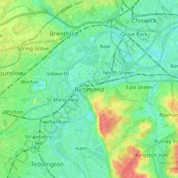
Name: Topografische Karte Richmond, Höhe, Relief.
Durchschnittliche Höhe: 17 m
Minimale Höhe: 0 m
Maximale Höhe: 63 m
Andere topografische Karten
Klicken Sie auf eine Karte, um ihre Topografie, ihre Höhe und ihr Relief anzuzeigen.
Hyde Park
United Kingdom > England > London
"It consists of a screen of handsome fluted Ionic columns, with three carriage entrance archways, two-foot entrances, a lodge, etc. The extent of the whole frontage is about 107 ft (33 m). The central entrance has a bold projection: the entablature is supported by four columns; and the volutes of the capitals…
Durchschnittliche Höhe: 25 m
Wimbledon Common
United Kingdom > England > London
Putney Heath is around 160 hectares (400 acres) in size and sits at approximately 45 metres (148 feet) above sea level. Because of its elevation, from 1796 to 1816 Putney Heath hosted a station in the shutter telegraph chain, which connected the Admiralty in London to its naval ships in Portsmouth. This was…
Durchschnittliche Höhe: 35 m
River Brent
United Kingdom > England > London
The catchment area varies in altitude from just over 150 metres above sea level at Bushey Heath, on its northern watershed, to barely 10 metres at the confluence of the Brent with the Thames at Brentford.
Durchschnittliche Höhe: 36 m
London Borough of Hammersmith and Fulham
United Kingdom > England > London
Durchschnittliche Höhe: 16 m
Gorilla Circus Regents Park Flying Trapeze School
United Kingdom > England > London > Camden Town
Durchschnittliche Höhe: 41 m
Norwood Grove
United Kingdom > England > London
After Anderson died, ownership passed to the Nettlefold family and subsequently to Frederick Nettlefold the brother of Joseph Nettlefold and a member of the family that founded the Nettlefolds Ltd. engineering firm which later became GKN. Nettlefold is commemorated, as a result of his charitable works, by a…
Durchschnittliche Höhe: 58 m