Geolokalisieren

Topografische Karte Croydon

Klicken Sie auf die Karte, um die Höhe anzuzeigen.

Croydon

Several apartment developments, for instance Altitude 25 (completed 2010), have been built in recent years, and several more are being built or planned. The construction of Saffron Square, which includes a 43-storey tower, began on Wellesley Road in 2011 and was completed in 2016. Other developments with towers over 50 floors high have been given planning approval. These include the 54-storey "Menta Tower" in Cherry Orchard Road near East Croydon station, and a 55-storey tower at One Lansdowne Road, on which construction was set to begin in early 2013. The latter is set to be Britain's tallest block of flats, including office space, a four-star hotel and a health club.

Wikipedia (CC-BY-SA 3.0)

Über diese Karte

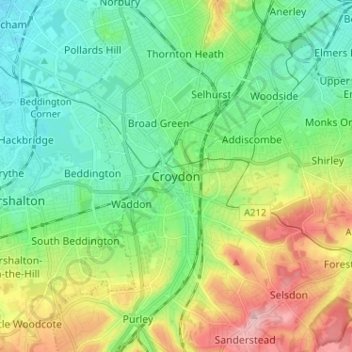
Name: Topografische Karte Croydon, Höhe, Relief.

Ort: Croydon, Greater London, England, CR0 1SZ, United Kingdom (51.33130 -0.14196 51.41130 -0.06196)

Durchschnittliche Höhe: 70 m

Minimale Höhe: 20 m

Maximale Höhe: 175 m

Andere topografische Karten

Klicken Sie auf eine Karte, um ihre Topografie, ihre Höhe und ihr Relief anzuzeigen.

Whitstable

United Kingdom > England > Kent

Durchschnittliche Höhe: 15 m

Sheffield

United Kingdom > England

Durchschnittliche Höhe: 168 m

Kent

United Kingdom > England

Kent was also the location of the largest number of art schools in the country during the nineteenth century, estimated by the art historian David Haste, to approach two hundred. This is believed to be the result of Kent being a front line county during the Napoleonic Wars. At this time, before the invention…

Durchschnittliche Höhe: 37 m

Greater Manchester

United Kingdom > England

Durchschnittliche Höhe: 141 m

Bristol

United Kingdom > England > City of Bristol

Durchschnittliche Höhe: 55 m

South East England

United Kingdom > England

Near Weybridge are the UK headquarters of Sony with SSP Group (situated in Byfleet) and Procter & Gamble (next door to each other on The Heights Business Park near the former Brooklands racing circuit) with Kia Motors UK and Petroleum Geo-Services UK, and Gallaher Group (cigarettes) is to the north, next to…

Durchschnittliche Höhe: 69 m

London

United Kingdom > England

London's topography is characterized by a gently rolling terrain shaped by the River Thames and its tributaries. The city lies within the London Basin, a natural depression bordered by higher grounds such as the North Downs to the south and the Chiltern Hills to the northwest. The Thames flows west to east,…

Durchschnittliche Höhe: 66 m

Wirral

United Kingdom > England

Durchschnittliche Höhe: 21 m

Somerset

United Kingdom > England

Durchschnittliche Höhe: 87 m

Peak District National Park

United Kingdom > England > Derbyshire

Durchschnittliche Höhe: 225 m

Bath

United Kingdom > England > Bath and North East Somerset

Bath is in the Avon Valley and is surrounded by limestone hills as it is near the southern edge of the Cotswolds, a designated Area of Outstanding Natural Beauty, and the limestone Mendip Hills rise around 7 miles (11 km) south of the city. The hills that surround and make up the city have a maximum altitude…

Durchschnittliche Höhe: 100 m

Norwich

United Kingdom > England > Norfolk

Durchschnittliche Höhe: 28 m

Leeds

United Kingdom > England

Durchschnittliche Höhe: 96 m

Birmingham

United Kingdom > England

Birmingham is a snowy city relative to other large UK conurbations, due to its inland location and comparatively high elevation. Between 1961 and 1990 Birmingham Airport averaged 13.0 days of snow lying annually, compared to 5.33 at London Heathrow. Snow showers often pass through the city via the Cheshire gap…

Durchschnittliche Höhe: 138 m

Liverpool

United Kingdom > England

Durchschnittliche Höhe: 26 m

Vielen Dank für die Unterstützung dieser Website ❤️
Spenden

Rüsten Sie sich für Ihr nächstes Abenteuer:

Als Amazon-Partner erhält diese Website eine Provision für qualifizierte Käufe, ohne zusätzliche Kosten für Sie.

Nottingham

United Kingdom > England > Nottinghamshire

Durchschnittliche Höhe: 56 m

Thornbury

United Kingdom > England > Herefordshire

Durchschnittliche Höhe: 180 m

Rillington

United Kingdom > England > North Yorkshire > Rillington

Durchschnittliche Höhe: 26 m

East Anglia

United Kingdom > England

Durchschnittliche Höhe: 29 m

Lincolnshire

United Kingdom > England

Lincolnshire has had a comparatively quiet history, being a rural county which was not heavily industrialised and faced little threat of invasion. In the Roman era Lincoln was a major settlement, called Lindum Colonia. In the fifth century what would become the county was settled by the invading Angles, who…

Durchschnittliche Höhe: 26 m

East of England

United Kingdom > England

The East of England region has the lowest elevation range in the UK. Twenty percent of the region is below mean sea level, most of this in North Cambridgeshire, Norfolk and on the Essex Coast. Most of the remaining area is of low elevation, with extensive glacial deposits. The Fens, a large area of reclaimed…

Durchschnittliche Höhe: 39 m

North West England

United Kingdom > England

Durchschnittliche Höhe: 118 m

Sussex

United Kingdom > England

Durchschnittliche Höhe: 39 m

Mansfield

United Kingdom > England > Nottinghamshire

Durchschnittliche Höhe: 117 m

Vielen Dank für die Unterstützung dieser Website ❤️
Spenden

Yorkshire

United Kingdom > England

In Yorkshire there is a very close relationship between the major topographical areas and the geological period in which they were formed. The Pennine chain of hills in the west is of Carboniferous origin. The central vale is Permo-Triassic. The North York Moors in the north-east of the county are Jurassic in…

Durchschnittliche Höhe: 130 m

North Norfolk

United Kingdom > England > Norfolk

Durchschnittliche Höhe: 26 m

Todmorden

United Kingdom > England > Calderdale

Todmorden Town Hall, which was designed in the Neo-Classical style, dominates the centre of the town. The building straddles the Walsden Water, a tributary of the River Calder, and was situated in both Lancashire and Yorkshire until the administrative county boundary was moved on 1 January 1888. Designed by…

Durchschnittliche Höhe: 311 m

North East England

United Kingdom > England

North East England has a Marine west coast climate (generally found along the west coast of middle latitude continents) with narrower temperature ranges than the south of England and sufficient precipitation in all months. Summers and winters are mild rather than extremely hot or cold, due to the strong…

Durchschnittliche Höhe: 165 m

Hampstead Heath

United Kingdom > England > London

Durchschnittliche Höhe: 94 m

Vielen Dank für die Unterstützung dieser Website ❤️
Spenden

Malvern Hills

United Kingdom > England > Worcestershire

Durchschnittliche Höhe: 82 m

New Forest National Park

United Kingdom > England > Hampshire

Durchschnittliche Höhe: 34 m

River Thames

United Kingdom > England

Durchschnittliche Höhe: 84 m

Lincolnshire

United Kingdom > England

Durchschnittliche Höhe: 28 m

Vielen Dank für die Unterstützung dieser Website ❤️
Spenden

East Riding of Yorkshire

United Kingdom > England

The western part of the district in the Vale of York borders on and is drained by the River Derwent. The landscape is generally low-lying and flat although minor ridges and glacial moraines provide some variations in topography. Where there are dry sandy soils there are remnants of historic heathlands and…

Durchschnittliche Höhe: 30 m

Dartmoor National Park

United Kingdom > England > Devon

Rainfall tends to be associated with Atlantic depressions or with convection. In summer, convection caused by solar surface heating sometimes forms shower clouds and a large proportion of rainfall falls from showers and thunderstorms at this time of year. The wettest months are November and December and on the…

Durchschnittliche Höhe: 239 m

City of Bristol

United Kingdom > England

Durchschnittliche Höhe: 80 m

Suffolk

United Kingdom > England

The west of the county lies on more resistant Cretaceous chalk. This chalk is responsible for a sweeping tract of largely downland landscapes that stretches from Dorset in the south west to Dover in the south east and north through East Anglia to the Yorkshire Wolds. The chalk is less easily eroded so forms…

Durchschnittliche Höhe: 35 m

Norfolk

United Kingdom > England

Durchschnittliche Höhe: 23 m

Isle of Wight

United Kingdom > England

Durchschnittliche Höhe: 17 m

West Midlands

United Kingdom > England > Warwickshire

Durchschnittliche Höhe: 113 m

Herefordshire

United Kingdom > England

Durchschnittliche Höhe: 159 m

North Yorkshire

United Kingdom > England

Durchschnittliche Höhe: 153 m

Cornwall

United Kingdom > England

The interior of the county consists of a roughly east–west spine of infertile and exposed upland, with a series of granite intrusions, such as Bodmin Moor, which contains the highest land within Cornwall. From east to west, and with approximately descending altitude, these are Bodmin Moor, Hensbarrow north…

Durchschnittliche Höhe: 55 m

Vielen Dank für die Unterstützung dieser Website ❤️
Spenden

Wigan

United Kingdom > England

Durchschnittliche Höhe: 74 m

Cheltenham

United Kingdom > England > Gloucestershire

Durchschnittliche Höhe: 109 m

Stockport

United Kingdom > England

Durchschnittliche Höhe: 95 m

Manchester

United Kingdom > England

Durchschnittliche Höhe: 66 m

Farnham

United Kingdom > England > Surrey > Waverley

Farnham lies in the valley of the North Branch of the River Wey, which rises near Alton, merges with the South Branch at Tilford, and joins the River Thames at Weybridge. The mainly east-west alignment of the ridges and valleys has influenced the development of road and rail communications. The most prominent…

Durchschnittliche Höhe: 100 m

Vielen Dank für die Unterstützung dieser Website ❤️
Spenden

Rüsten Sie sich für Ihr nächstes Abenteuer:

Als Amazon-Partner erhält diese Website eine Provision für qualifizierte Käufe, ohne zusätzliche Kosten für Sie.

Derby

United Kingdom > England

Durchschnittliche Höhe: 70 m

Exeter

United Kingdom > England > Devon

The city of Exeter was established on the eastern bank of the River Exe on a ridge of land backed by a steep hill. It is at this point that the Exe, having just been joined by the River Creedy, opens onto a wide flood plain and estuary which results in quite common flooding. Historically this was the lowest…

Durchschnittliche Höhe: 56 m

Gloucester

United Kingdom > England > Gloucestershire

Durchschnittliche Höhe: 36 m

Woking

United Kingdom > England > Surrey

Durchschnittliche Höhe: 38 m

Oxford

United Kingdom > England > Oxfordshire

Durchschnittliche Höhe: 81 m

Eastbourne

United Kingdom > England > East Sussex

Durchschnittliche Höhe: 36 m

Preston

United Kingdom > England > Lancashire

Durchschnittliche Höhe: 58 m

Ipswich

United Kingdom > England > Suffolk

Ipswich experiences an oceanic climate, like the rest of the British Isles, with a narrow range of temperature and rainfall spread evenly throughout the year. One of the two nearest for which data is available is East Bergholt, about 7 miles (11 km) south west of the town centre and at a similar elevation, and…

Durchschnittliche Höhe: 29 m

Cambridge

United Kingdom > England > Cambridge

The city, like most of the UK, has a maritime climate highly influenced by the Gulf Stream. Located in the driest region of Britain, Cambridge's rainfall averages around 570 mm (22.44 in) per year, around half the national average, with some years occasionally falling into the semi-arid (under 500 mm (19.69…

Durchschnittliche Höhe: 18 m

Stevenage

United Kingdom > England > Hertfordshire

Durchschnittliche Höhe: 108 m

Vielen Dank für die Unterstützung dieser Website ❤️
Spenden

Colchester

United Kingdom > England > Essex

Durchschnittliche Höhe: 28 m

Coventry

United Kingdom > England

Durchschnittliche Höhe: 99 m

Gateshead

United Kingdom > England > Tyne and Wear

Durchschnittliche Höhe: 81 m

Barnsley

United Kingdom > England

Durchschnittliche Höhe: 139 m

Guildford

United Kingdom > England > Surrey

Durchschnittliche Höhe: 74 m

Vielen Dank für die Unterstützung dieser Website ❤️
Spenden

Rüsten Sie sich für Ihr nächstes Abenteuer:

Als Amazon-Partner erhält diese Website eine Provision für qualifizierte Käufe, ohne zusätzliche Kosten für Sie.

Warrington

United Kingdom > England

Durchschnittliche Höhe: 32 m

Bugbrooke

United Kingdom > England > West Northamptonshire > Bugbrooke

Durchschnittliche Höhe: 91 m

Pakenham

United Kingdom > England > Suffolk > West Suffolk

Durchschnittliche Höhe: 45 m

Redditch

United Kingdom > England > Worcestershire

Durchschnittliche Höhe: 99 m

Monk Soham

United Kingdom > England > Suffolk > Mid Suffolk

Durchschnittliche Höhe: 57 m

Wendling Beck

United Kingdom > England > Norfolk > Breckland District

Durchschnittliche Höhe: 49 m

Yarnscombe

United Kingdom > England > Devon > Torridge District > Yarnscombe

Durchschnittliche Höhe: 129 m

Michaelstow

United Kingdom > England > Cornwall

Durchschnittliche Höhe: 139 m

Eastfield

United Kingdom > England > North Yorkshire > Eastfield

Durchschnittliche Höhe: 61 m

Bewl Water

United Kingdom > England > East Sussex > Rother > Ticehurst

Durchschnittliche Höhe: 92 m

North Kelsey CP

United Kingdom > England > Lincolnshire > West Lindsey

Durchschnittliche Höhe: 14 m

Hoggeston

United Kingdom > England > Buckinghamshire

Durchschnittliche Höhe: 121 m

Buxton

United Kingdom > England > Derbyshire > High Peak

Buxton has an oceanic climate with short, mild summers and long, cool winters. At about 1,000 feet (300 m) above sea level, As the highest market town in England, Buxton's elevation makes it cooler and wetter than surrounding towns, with a daytime temperature typically about 2 °C lower than Manchester.

Durchschnittliche Höhe: 334 m

Horsington

United Kingdom > England > Somerset

Durchschnittliche Höhe: 92 m

Threapwood

United Kingdom > England > Cheshire West and Chester

Durchschnittliche Höhe: 46 m

Croydon

United Kingdom > England > Cambridgeshire > South Cambridgeshire

Durchschnittliche Höhe: 53 m

Falmer

United Kingdom > England > East Sussex > Lewes

Durchschnittliche Höhe: 116 m

Lake District National Park

United Kingdom > England

The Lake District is a roughly circular upland massif, deeply dissected by a broadly radial pattern of major valleys which are largely the result of repeated glaciations over the last 2 million years. The apparent radial pattern is not from a central dome, but from an axial watershed extending from St Bees…

Durchschnittliche Höhe: 206 m

High Wycombe

United Kingdom > England > Buckinghamshire

Durchschnittliche Höhe: 124 m

Reading

United Kingdom > England

Jane Austen attended Reading Ladies Boarding School, based in the Abbey Gateway, in 1784–1786. Mary Russell Mitford lived in Reading for a number of years and then spent the rest of her life just outside the town at Three Mile Cross and Swallowfield. The fictional Belford Regis of her eponymous novel, first…

Durchschnittliche Höhe: 54 m

Yorkshire Dales National Park

United Kingdom > England

Durchschnittliche Höhe: 298 m

Cheshire

United Kingdom > England

Durchschnittliche Höhe: 103 m

Forest of Dean

United Kingdom > England > Gloucestershire

Durchschnittliche Höhe: 86 m

Brighton and Hove

United Kingdom > England

Durchschnittliche Höhe: 63 m

Northamptonshire

United Kingdom > England

Durchschnittliche Höhe: 97 m

Oxfordshire

United Kingdom > England

Durchschnittliche Höhe: 113 m

East Sussex

United Kingdom > England

Durchschnittliche Höhe: 43 m

Derbyshire

United Kingdom > England

Due to its central location in England and altitude range from 27 metres in the south to 636 metres in the north, Derbyshire contains many species at the edge of their UK distribution ranges. Some species with a predominantly northern British distribution are at the southern limit of their range, whilst others…

Durchschnittliche Höhe: 144 m

West Yorkshire

United Kingdom > England

Wakefield's Parish Church was raised to cathedral status in 1888 and after the elevation of Wakefield to diocese, Wakefield Council immediately sought city status and this was granted in July 1888. However the industrial revolution, which changed West and South Yorkshire significantly, led to the growth of…

Durchschnittliche Höhe: 172 m

Richmond Park

United Kingdom > England > London

Durchschnittliche Höhe: 26 m

Worcestershire

United Kingdom > England

Durchschnittliche Höhe: 99 m

Vielen Dank für die Unterstützung dieser Website ❤️
Spenden

Rüsten Sie sich für Ihr nächstes Abenteuer:

🧢Outdoor Cap - Sonnenschutz Cap für Wanderungen
🛏️Selbstaufblasbare Isomatte - Komfortable Schlafunterlage für Outdoor
Biwaksäcke - Minimalistischer Wetterschutz für Übernachtungen am Berg
🔥Camping-Gaskocher - Schnelle warme Mahlzeiten überall in der Natur
🩴Camping Sandalen - Bequeme Sandalen für Basislager

Als Amazon-Partner erhält diese Website eine Provision für qualifizierte Käufe, ohne zusätzliche Kosten für Sie.