
Topografische Karte Keystone Heights
Interaktive Karte
Klicken Sie auf die Karte, um die Höhe anzuzeigen.
Über diese Karte
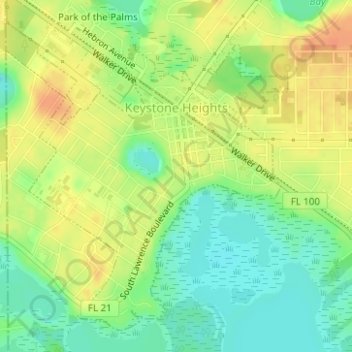
Name: Topografische Karte Keystone Heights, Höhe, Relief.
Ort: Keystone Heights, Clay County, Florida, United States (29.76894 -82.04661 29.79263 -82.02162)
Durchschnittliche Höhe: 41 m
Minimale Höhe: 21 m
Maximale Höhe: 59 m
Andere topografische Karten
Klicken Sie auf eine Karte, um ihre Topografie, ihre Höhe und ihr Relief anzuzeigen.
Middleburg
United States > Florida > Clay County
Middleburg, Clay County, Florida, United States
Durchschnittliche Höhe: 23 m
Green Cove Springs
United States > Florida > Clay County
Green Cove Springs, Clay County, Florida, United States
Durchschnittliche Höhe: 8 m
Orange Park
United States > Florida > Clay County
Orange Park, Clay County, Florida, United States
Durchschnittliche Höhe: 5 m
Fleming Island
United States > Florida > Clay County
Fleming Island, Clay County, Florida, 32003, United States
Durchschnittliche Höhe: 19 m
Bellair
United States > Florida > Clay County
Bellair, Clay County, Florida, 32073, United States
Durchschnittliche Höhe: 12 m
Highland
United States > Florida > Clay County
Highland, Clay County, Florida, United States
Durchschnittliche Höhe: 55 m
Oakleaf
United States > Florida > Clay County > Oakleaf
Oakleaf, Clay County, Florida, 32222, United States
Durchschnittliche Höhe: 18 m
Middleburg
United States > Florida > Clay County > Middleburg
Middleburg, Clay County, Florida, 32068, United States
Durchschnittliche Höhe: 10 m
Asbury Lake
United States > Florida > Clay County
Asbury Lake, Clay County, Florida, United States
Durchschnittliche Höhe: 22 m
Bellair-Meadowbrook Terrace
United States > Florida > Clay County > Bellair
Bellair-Meadowbrook Terrace, Bellair, Clay County, Florida, 32073, United States
Durchschnittliche Höhe: 10 m