
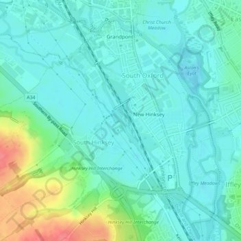
Topografische Karte Hinksey Stream
Interaktive Karte
Klicken Sie auf die Karte, um die Höhe anzuzeigen.
Über diese Karte
Name: Topografische Karte Hinksey Stream, Höhe, Relief.
Durchschnittliche Höhe: 65 m
Minimale Höhe: 50 m
Maximale Höhe: 114 m
Andere topografische Karten
Klicken Sie auf eine Karte, um ihre Topografie, ihre Höhe und ihr Relief anzuzeigen.
Headington Hill Park
United Kingdom > England > Oxford
Headington Hill Park, New Marston, Oxford, Oxfordshire, South East, England, United Kingdom
Durchschnittliche Höhe: 74 m
Binsey
United Kingdom > England > Oxford > Binsey
Binsey, Oxford, Oxfordshire, South East England, England, OX2 0NG, United Kingdom
Durchschnittliche Höhe: 69 m
Blackbird Leys
United Kingdom > England > Oxford
Blackbird Leys, Oxford, Oxfordshire, South East, England, United Kingdom
Durchschnittliche Höhe: 68 m
Angel and Greyhound Meadow
United Kingdom > England > Oxford
Angel and Greyhound Meadow, New Marston, Oxford, Oxfordshire, South East, England, United Kingdom
Durchschnittliche Höhe: 68 m
Godstow
United Kingdom > England > Oxford > Godstow
Godstow, Oxford, Oxfordshire, South East, England, OX2 8PN, United Kingdom
Durchschnittliche Höhe: 71 m
Bury Knowle Park
United Kingdom > England > Oxford
Bury Knowle Park, Headington, Oxford, Oxfordshire, South East, England, United Kingdom
Durchschnittliche Höhe: 94 m
Risinghurst and Sandhills
United Kingdom > England > Oxford
Risinghurst and Sandhills, Oxford, Oxfordshire, South East, England, United Kingdom
Durchschnittliche Höhe: 107 m
Castle Mill Stream
United Kingdom > England > Oxford
Castle Mill Stream, Oxford, Oxfordshire, South East, England, OX1 1HF, United Kingdom
Durchschnittliche Höhe: 61 m