
Topografische Karte Nail Can Hill
Interaktive Karte
Klicken Sie auf die Karte, um die Höhe anzuzeigen.
Über diese Karte
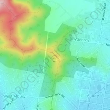
Name: Topografische Karte Nail Can Hill, Höhe, Relief.
Durchschnittliche Höhe: 223 m
Minimale Höhe: 159 m
Maximale Höhe: 403 m
Andere topografische Karten
Klicken Sie auf eine Karte, um ihre Topografie, ihre Höhe und ihr Relief anzuzeigen.
Splitters Creek
Australia > New South Wales > Albury
The Splitters Creek valley is classed as a very high fire risk by the NSW Rural Fire Service (one of two in NSW) due to the topography and the access with only 1 road in and out.
Durchschnittliche Höhe: 214 m