
Topografische Karte Variegated Glacier
Interaktive Karte
Klicken Sie auf die Karte, um die Höhe anzuzeigen.
Über diese Karte
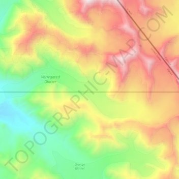
Name: Topografische Karte Variegated Glacier, Höhe, Relief.
Durchschnittliche Höhe: 1.241 m
Minimale Höhe: 227 m
Maximale Höhe: 2.603 m
Andere topografische Karten
Klicken Sie auf eine Karte, um ihre Topografie, ihre Höhe und ihr Relief anzuzeigen.
Chugach State Park
United States of America > Alaska > Anchorage
Chugach State Park, Anchorage, Alaska, 99540, United States of America
Durchschnittliche Höhe: 712 m
Northway
United States of America > Alaska
Northway, Unorganized Borough, Alaska, United States of America
Durchschnittliche Höhe: 526 m
Russian River
United States of America > Alaska
Russian River, Kodiak Island, Alaska, United States of America
Durchschnittliche Höhe: 217 m
Avon Island
United States of America > Alaska
Avon Island, Wrangell, Alaska, United States of America
Durchschnittliche Höhe: 1 m
Shishaldin Volcano
United States of America > Alaska
Shishaldin Volcano, Aleutians East, Alaska, United States of America
Durchschnittliche Höhe: 2.134 m
Signal Island
United States of America > Alaska > Sitka
Signal Island, Sitka, Alaska, United States of America
Durchschnittliche Höhe: 0 m
Delta River
United States of America > Alaska
Delta River, Unorganized Borough, Alaska, United States of America
Durchschnittliche Höhe: 953 m
Adak
United States of America > Alaska > Adak
Adak, Unorganized Borough, Alaska, 99546, United States of America
Durchschnittliche Höhe: 141 m
Kasilof
United States of America > Alaska > Soldotna
Kasilof, Kalifornsky Beach Road, Soldotna, Kenai Peninsula, Alaska, 99610, United States of America
Durchschnittliche Höhe: 39 m
Brooks Range
United States of America > Alaska
Brooks Range, North Slope, Alaska, United States of America
Durchschnittliche Höhe: 2.115 m
Unalakleet
United States of America > Alaska > Unalakleet
Unalakleet, Nome, Alaska, 99684, United States of America
Durchschnittliche Höhe: 26 m
Hoonah-Angoon
United States of America > Alaska
Hoonah-Angoon, Taylor Lake Trail, Unorganized Borough, Alaska, United States of America
Durchschnittliche Höhe: 453 m