
Topografische Karte Bolton-by-Bowland
Interaktive Karte
Klicken Sie auf die Karte, um die Höhe anzuzeigen.
Über diese Karte
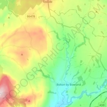
Name: Topografische Karte Bolton-by-Bowland, Höhe, Relief.
Durchschnittliche Höhe: 193 m
Minimale Höhe: 72 m
Maximale Höhe: 394 m
Andere topografische Karten
Klicken Sie auf eine Karte, um ihre Topografie, ihre Höhe und ihr Relief anzuzeigen.
Clitheroe
United Kingdom > England > Ribble Valley > Clitheroe
Clitheroe, Lancashire, North West England, England, BB7 2BT, United Kingdom
Durchschnittliche Höhe: 125 m
Bolton by Bowland
United Kingdom > England > Ribble Valley > Bolton by Bowland
Bolton by Bowland, Ribble Valley, Lancashire, North West England, England, BB7 4NQ, United Kingdom
Durchschnittliche Höhe: 133 m
Billington and Langho
United Kingdom > England > Ribble Valley
Billington and Langho, Ribble Valley, Lancashire, North West England, England, United Kingdom
Durchschnittliche Höhe: 100 m
Simonstone
United Kingdom > England > Ribble Valley > Simonstone
Simonstone, Ribble Valley, Lancashire, North West England, England, United Kingdom
Durchschnittliche Höhe: 135 m
Brennand River
United Kingdom > England > Ribble Valley
Brennand River, Ribble Valley, Lancashire, North West England, England, BB7 3BL, United Kingdom
Durchschnittliche Höhe: 326 m
Whitendale River
United Kingdom > England > Ribble Valley
Whitendale River, Ribble Valley, Lancashire, North West England, England, BB7 3BL, United Kingdom
Durchschnittliche Höhe: 356 m
Aighton, Bailey and Chaigley
United Kingdom > England > Ribble Valley
Aighton, Bailey and Chaigley, Ribble Valley, Lancashire, North West England, England, United Kingdom
Durchschnittliche Höhe: 122 m
River Dunsop
United Kingdom > England > Ribble Valley
River Dunsop, Ribble Valley, Lancashire, North West England, England, BB7 3BD, United Kingdom
Durchschnittliche Höhe: 244 m