
Topografische Karte Westland
Interaktive Karte
Klicken Sie auf die Karte, um die Höhe anzuzeigen.
Über diese Karte
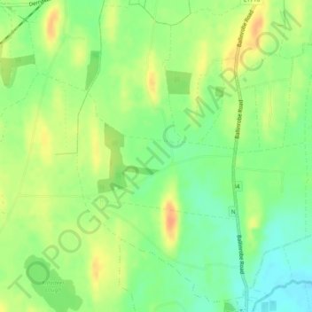
Name: Topografische Karte Westland, Höhe, Relief.
Durchschnittliche Höhe: 43 m
Minimale Höhe: 24 m
Maximale Höhe: 62 m
Andere topografische Karten
Klicken Sie auf eine Karte, um ihre Topografie, ihre Höhe und ihr Relief anzuzeigen.
Acres
Acres, Killeen ED, Tuam Municipal District, County Galway, Connacht, Irlande
Durchschnittliche Höhe: 73 m
Knocknagoran
Knocknagoran, Drummullagh, The Municipal District of Dundalk, County Louth, Leinster, Irlande
Durchschnittliche Höhe: 39 m
Cappalusk ED
Cappalusk ED, Faha, County Galway, Connacht, Irlande
Durchschnittliche Höhe: 96 m
Maryborough
Maryborough, Portlaoise Rural ED, The Municipal District of Portlaoise, County Laois, Leinster, R32 KV20, Irlande
Durchschnittliche Höhe: 96 m
Lough Mask
Lough Mask, R300, Cappaghduff East, Cappaghduff ED, Castlebar Municipal District, County Mayo, Connacht, Irlande
Durchschnittliche Höhe: 68 m
Cathair na Gaillimhe
Irlande > Cathair na Gaillimhe
Galway, Cathair na Gaillimhe, County Galway, Connacht, H91 YD86, Irlande
Durchschnittliche Höhe: 26 m
Ballycroy National Park
Ballycroy National Park, Scardaun, Ballycroy South ED, Westport-Belmullet Municipal District, County Mayo, Connacht, Irlande
Durchschnittliche Höhe: 152 m
Lough Corrib
Lough Corrib, Carrowmoreknock Pier, Carrowmoreknock, Wormhole ED, Conamara Municipal District, County Galway, Connacht, Irlande
Durchschnittliche Höhe: 46 m
île d'Achill
île d'Achill, Westport-Belmullet Municipal District, County Mayo, Connacht, Irlande
Durchschnittliche Höhe: 42 m
Letterfrack
Letterfrack, Ballynakill ED, Conamara Municipal District, County Galway, Connacht, Irlande
Durchschnittliche Höhe: 58 m
Cherry Orchard
Cherry Orchard, Merchants Quay E ED, Dublin 8, Dublin, County Dublin, Leinster, Irlande
Durchschnittliche Höhe: 25 m