Geolokalisieren

Topografische Karte Lurgan

Interaktive Karte

Klicken Sie auf die Karte, um die Höhe anzuzeigen.

Über diese Karte

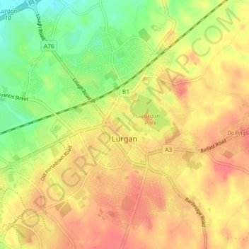
Name: Topografische Karte Lurgan, Höhe, Relief.

Ort: Lurgan, County Armagh, Ulster, Northern Ireland, United Kingdom (54.44378 -6.37463 54.48257 -6.30218)

Durchschnittliche Höhe: 48 m

Minimale Höhe: 15 m

Maximale Höhe: 70 m

Andere topografische Karten

Klicken Sie auf eine Karte, um ihre Topografie, ihre Höhe und ihr Relief anzuzeigen.

Canary

United Kingdom > Northern Ireland > County Armagh

Canary, County Armagh, Northern Ireland, United Kingdom

Durchschnittliche Höhe: 19 m

Armagh

United Kingdom > Northern Ireland > County Armagh > Armagh

Armagh, County Armagh, Northern Ireland, BT61 7DJ, United Kingdom

Durchschnittliche Höhe: 85 m

Derrynoose

United Kingdom > Northern Ireland > County Armagh

Derrynoose, County Armagh, Northern Ireland, BT60 3EZ, United Kingdom

Durchschnittliche Höhe: 163 m

Portadown

United Kingdom > Northern Ireland > County Armagh

Portadown, County Armagh, Northern Ireland, BT62 1BF, United Kingdom

Durchschnittliche Höhe: 28 m

Madden

United Kingdom > Northern Ireland > County Armagh

Madden, County Armagh, Ulster, Northern Ireland, BT60 3LR, United Kingdom

Durchschnittliche Höhe: 103 m

Armagh

United Kingdom > Northern Ireland > County Armagh > Milford

Armagh, Milford, County Armagh, Ulster, Northern Ireland, United Kingdom

Durchschnittliche Höhe: 100 m

Forkhill

United Kingdom > Northern Ireland > County Armagh

Forkhill, County Armagh, Ulster, Northern Ireland, BT35 9SN, United Kingdom

Durchschnittliche Höhe: 104 m

Richhill

United Kingdom > Northern Ireland > County Armagh

Richhill, County Armagh, Northern Ireland, BT61 9QR, United Kingdom

Durchschnittliche Höhe: 66 m

Keady

United Kingdom > Northern Ireland > County Armagh

Keady, County Armagh, Ulster, Northern Ireland, BT60 3RW, United Kingdom

Durchschnittliche Höhe: 158 m

Markethill

United Kingdom > Northern Ireland > County Armagh

Markethill, County Armagh, Northern Ireland, BT60 1PW, United Kingdom

Durchschnittliche Höhe: 106 m

Poyntzpass

United Kingdom > Northern Ireland > County Armagh

Poyntzpass, County Armagh, Ulster, Northern Ireland, BT35 6SL, United Kingdom

Durchschnittliche Höhe: 61 m

Craigavon

United Kingdom > Northern Ireland > County Armagh

Craigavon, County Armagh, Ulster, Northern Ireland, BT64 3AE, United Kingdom

Durchschnittliche Höhe: 34 m

Killylea

United Kingdom > Northern Ireland > County Armagh > Armagh

Killylea, Armagh, County Armagh, Northern Ireland, BT60 4LN, United Kingdom

Durchschnittliche Höhe: 73 m

Charlestown

United Kingdom > Northern Ireland > County Armagh

Charlestown, County Armagh, Ulster, Northern Ireland, BT62 1LR, United Kingdom

Durchschnittliche Höhe: 16 m

Mullaghbawn

United Kingdom > Northern Ireland > County Armagh > Mullaghbawn

Mullaghbawn, County Armagh, Ulster, Northern Ireland, BT35 9TP, United Kingdom

Durchschnittliche Höhe: 127 m