
Topografische Karte Blackdown
Interaktive Karte
Klicken Sie auf die Karte, um die Höhe anzuzeigen.
Über diese Karte
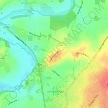
Name: Topografische Karte Blackdown, Höhe, Relief.
Durchschnittliche Höhe: 69 m
Minimale Höhe: 47 m
Maximale Höhe: 99 m
Andere topografische Karten
Klicken Sie auf eine Karte, um ihre Topografie, ihre Höhe und ihr Relief anzuzeigen.
Norton Lindsey
United Kingdom > England > Warwick > Norton Lindsey
Norton Lindsey, Warwick, Warwickshire, West Midlands, England, United Kingdom
Durchschnittliche Höhe: 93 m
Beausale
United Kingdom > England > Warwick > Beausale
Beausale, Beausale, Haseley, Honiley and Wroxall, Warwick, Warwickshire, West Midlands, England, CV35 7NR, United Kingdom
Durchschnittliche Höhe: 112 m
Kenilworth Castle
United Kingdom > England > Warwick
Kenilworth Castle, Purlieu Lane, Kenilworth, Warwick, Warwickshire, West Midlands, England, CV8 1PQ, United Kingdom
Durchschnittliche Höhe: 87 m
Bishops Tachbrook
United Kingdom > England > Warwick > Bishops Tachbrook
Bishops Tachbrook, Warwick, Warwickshire, West Midlands, England, CV33 9RJ, United Kingdom
Durchschnittliche Höhe: 71 m
Stoneleigh
United Kingdom > England > Warwick > Stoneleigh
Stoneleigh, Warwick, Warwickshire, West Midlands, England, CV8 3DH, United Kingdom
Durchschnittliche Höhe: 72 m
Beausale, Haseley, Honiley and Wroxall
United Kingdom > England > Warwick
Beausale, Haseley, Honiley and Wroxall, Warwick, Warwickshire, West Midlands, England, United Kingdom
Durchschnittliche Höhe: 111 m