
Topografische Karte Leith Links
Interaktive Karte
Klicken Sie auf die Karte, um die Höhe anzuzeigen.
Über diese Karte
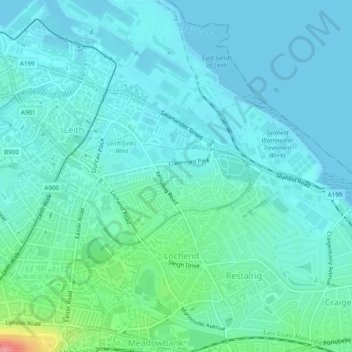
Name: Topografische Karte Leith Links, Höhe, Relief.
Durchschnittliche Höhe: 15 m
Minimale Höhe: 0 m
Maximale Höhe: 89 m
Andere topografische Karten
Klicken Sie auf eine Karte, um ihre Topografie, ihre Höhe und ihr Relief anzuzeigen.
Edinburgh
United Kingdom > Scotland > Edinburgh
Some have called Edinburgh the Athens of the North for a variety of reasons. The earliest comparison between the two cities showed that they had a similar topography, with the Castle Rock of Edinburgh performing a similar role to the Athenian Acropolis. Both of them had flatter, fertile agricultural land…
Durchschnittliche Höhe: 104 m
Pentland Hills Regional Park
United Kingdom > Scotland > Edinburgh > Peggyslea
Durchschnittliche Höhe: 249 m
Swanston
United Kingdom > Scotland > Edinburgh > Swanston
The area was traditionally seen as two farm estates: Easter Swanston owned by the Ross family; and Wester Swanston owned by the Foulis family. The two were united in 1749 when the Trotters of Mortonhall (who had bought Wester Swanston in 1670) also acquired Easter Swanston. The Trotter family planted the…
Durchschnittliche Höhe: 232 m