
Topografische Karte Wolfe Island
Interaktive Karte
Klicken Sie auf die Karte, um die Höhe anzuzeigen.
Über diese Karte
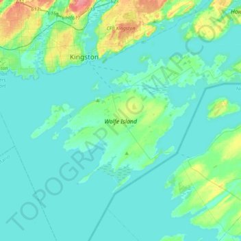
Name: Topografische Karte Wolfe Island, Höhe, Relief.
Durchschnittliche Höhe: 81 m
Minimale Höhe: 71 m
Maximale Höhe: 134 m
Andere topografische Karten
Klicken Sie auf eine Karte, um ihre Topografie, ihre Höhe und ihr Relief anzuzeigen.
Long Point
Canada > Ontario > Frontenac Islands
Long Point, Frontenac Islands, Frontenac County, Eastern Ontario, Ontario, Canada
Durchschnittliche Höhe: 73 m
Wolfe Island
Canada > Ontario > Frontenac Islands
Wolfe Island, Frontenac Islands, Frontenac County, Eastern Ontario, Ontario, Canada
Durchschnittliche Höhe: 101 m
Frontenac Islands
Canada > Ontario > Frontenac Islands
Frontenac Islands, Frontenac County, Eastern Ontario, Ontario, Canada
Durchschnittliche Höhe: 84 m