
Topografische Karte Mont Jacques-Cartier
Interaktive Karte
Klicken Sie auf die Karte, um die Höhe anzuzeigen.
Über diese Karte
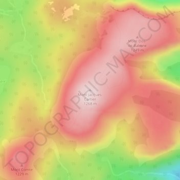
Name: Topografische Karte Mont Jacques-Cartier, Höhe, Relief.
Durchschnittliche Höhe: 1.137 m
Minimale Höhe: 884 m
Maximale Höhe: 1.276 m
Le mont Jacques-Cartier est, avec ses 1 270 m d'altitude, le point culminant des monts Chic-Chocs et du Sud du Québec, dans les Appalaches. Il domine aussi le parc national de la Gaspésie. Il est possible d'observer des caribous à son sommet.
Andere topografische Karten
Klicken Sie auf eine Karte, um ihre Topografie, ihre Höhe und ihr Relief anzuzeigen.
Mont Olivine
Canada > Québec > La Haute-Gaspésie > Mont-Albert
Mont Olivine, Mont-Albert, La Haute-Gaspésie, Gaspésie–Îles-de-la-Madeleine, Québec, G4V 2E4, Canada
Durchschnittliche Höhe: 455 m
Lac de Mont-Louis
Canada > Québec > La Haute-Gaspésie > Mont-Albert
Lac de Mont-Louis, Mont-Albert, La Haute-Gaspésie, Gaspésie–Îles-de-la-Madeleine, Québec, Canada
Durchschnittliche Höhe: 505 m
Gaspésie
Canada > Québec > La Haute-Gaspésie > Mont-Albert
Gaspésie, Mont-Albert, La Haute-Gaspésie, Gaspésie–Îles-de-la-Madeleine, Québec, Canada
Durchschnittliche Höhe: 459 m
Parc national de la Gaspésie
Canada > Québec > La Haute-Gaspésie > Mont-Albert
Parc national de la Gaspésie, Mont-Albert, La Haute-Gaspésie, Gaspésie–Îles-de-la-Madeleine, Québec, G4V 2E4, Canada
Durchschnittliche Höhe: 440 m
Mont Lyall
Canada > Québec > La Haute-Gaspésie > Mont-Albert
Mont Lyall, Mont-Albert, La Haute-Gaspésie, Gaspésie–Îles-de-la-Madeleine, Québec, Canada
Durchschnittliche Höhe: 673 m
Mont Joseph-Fortin
Canada > Québec > La Haute-Gaspésie > Mont-Albert
Mont Joseph-Fortin, Mont-Albert, La Haute-Gaspésie, Gaspésie–Îles-de-la-Madeleine, Québec, Canada
Durchschnittliche Höhe: 914 m
Lac Simoneau
Canada > Québec > La Haute-Gaspésie > Mont-Albert
Lac Simoneau, Mont-Albert, La Haute-Gaspésie, Gaspésie–Îles-de-la-Madeleine, Québec, Canada
Durchschnittliche Höhe: 406 m
Lac Adam
Canada > Québec > La Haute-Gaspésie > Mont-Albert
Lac Adam, Mont-Albert, La Haute-Gaspésie, Gaspésie–Îles-de-la-Madeleine, Québec, Canada
Durchschnittliche Höhe: 525 m
Rapide Blanc
Canada > Québec > La Haute-Gaspésie > Mont-Albert
Rapide Blanc, Mont-Albert, La Haute-Gaspésie, Gaspésie–Îles-de-la-Madeleine, Québec, Canada
Durchschnittliche Höhe: 371 m
Cap-Seize
Canada > Québec > La Haute-Gaspésie > Mont-Albert
Cap-Seize, Mont-Albert, La Haute-Gaspésie, Gaspésie–Îles-de-la-Madeleine, Québec, Canada
Durchschnittliche Höhe: 279 m