
Topografische Karte Aqualate Mere
Interaktive Karte
Klicken Sie auf die Karte, um die Höhe anzuzeigen.
Über diese Karte
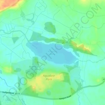
Name: Topografische Karte Aqualate Mere, Höhe, Relief.
Durchschnittliche Höhe: 74 m
Minimale Höhe: 62 m
Maximale Höhe: 103 m
Andere topografische Karten
Klicken Sie auf eine Karte, um ihre Topografie, ihre Höhe und ihr Relief anzuzeigen.
Stafford Castle
United Kingdom > England > Stafford
Stafford Castle, Castle Bank, Stafford, Staffordshire, West Midlands, England, ST17 9XE, United Kingdom
Durchschnittliche Höhe: 96 m
Barlaston
United Kingdom > England > Stafford > Barlaston
Barlaston, Stafford, Staffordshire, England, ST12 9DQ, United Kingdom
Durchschnittliche Höhe: 131 m
Tixall
United Kingdom > England > Stafford > Tixall
Tixall, Stafford, Staffordshire, West Midlands, England, ST18 0XT, United Kingdom
Durchschnittliche Höhe: 93 m
Sutton
United Kingdom > England > Stafford > Sutton
Sutton, Stafford, Staffordshire, West Midlands, England, TF10 8DQ, United Kingdom
Durchschnittliche Höhe: 83 m
Weston
United Kingdom > England > Stafford > Weston
Weston, Stafford, Staffordshire, West Midlands, England, ST18 0HX, United Kingdom
Durchschnittliche Höhe: 98 m
Mill Haft (BIFOR) Carbon Research Forest
United Kingdom > England > Stafford
Mill Haft (BIFOR) Carbon Research Forest, Norbury Road, Norbury, Stafford, Staffordshire, West Midlands, England, ST20 0PW, United Kingdom
Durchschnittliche Höhe: 105 m
Gnosall Heath
United Kingdom > England > Stafford > Gnosall Heath
Gnosall Heath, Stafford, Staffordshire, West Midlands, England, ST20 0BX, United Kingdom
Durchschnittliche Höhe: 108 m
Norbury Junction
United Kingdom > England > Stafford
Norbury Junction, Stafford, Staffordshire, West Midlands, England, ST20 0PN, United Kingdom
Durchschnittliche Höhe: 102 m
Woodlands Road
United Kingdom > England > Stafford
Woodlands Road, Stafford, Staffordshire, West Midlands, England, United Kingdom
Durchschnittliche Höhe: 85 m
Hopton Pools
United Kingdom > England > Stafford
Hopton Pools, Within Lane, Hopton and Coton, Stafford, Staffordshire, West Midlands, England, ST18 0AY, United Kingdom
Durchschnittliche Höhe: 117 m
Yarnfield and Cold Meece
United Kingdom > England > Stafford
Yarnfield and Cold Meece, Stafford, Staffordshire, West Midlands, England, United Kingdom
Durchschnittliche Höhe: 110 m
Hopton and Coton
United Kingdom > England > Stafford
Hopton and Coton, Stafford, Staffordshire, West Midlands, England, United Kingdom
Durchschnittliche Höhe: 101 m
Adbaston
United Kingdom > England > Stafford
Adbaston, Stafford, Staffordshire, West Midlands, England, United Kingdom
Durchschnittliche Höhe: 109 m