
Topografische Karte Gananoque Lake
Interaktive Karte
Klicken Sie auf die Karte, um die Höhe anzuzeigen.
Über diese Karte
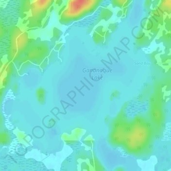
Name: Topografische Karte Gananoque Lake, Höhe, Relief.
Durchschnittliche Höhe: 90 m
Minimale Höhe: 81 m
Maximale Höhe: 130 m
Andere topografische Karten
Klicken Sie auf eine Karte, um ihre Topografie, ihre Höhe und ihr Relief anzuzeigen.
Gananoque River
Canada > Ontario > Leeds and the Thousand Islands > Willowbank
Gananoque River, Turn Around Road, Willowbank, Leeds and the Thousand Islands, Leeds and Grenville Counties, Eastern Ontario, Ontario, K7G 1G4, Canada
Durchschnittliche Höhe: 92 m
Southern Water
Canada > Ontario > Leeds and the Thousand Islands > Outlet
Southern Water, Outlet, Leeds and the Thousand Islands, Leeds and Grenville Counties, Eastern Ontario, Ontario, Canada
Durchschnittliche Höhe: 93 m
Ivy Lea
Canada > Ontario > Leeds and the Thousand Islands > Ivy Lea
Ivy Lea, Leeds and the Thousand Islands, Leeds and Grenville Counties, Eastern Ontario, Ontario, K0E 1L0, Canada
Durchschnittliche Höhe: 87 m
Gananoque Lake
Canada > Ontario > Leeds and the Thousand Islands
Gananoque Lake, Deryaw Road, Leeds and the Thousand Islands, Leeds and Grenville Counties, Eastern Ontario, Ontario, K0H 2N0, Canada
Durchschnittliche Höhe: 92 m