
Topografische Karte County Tyrone
Interaktive Karte
Klicken Sie auf die Karte, um die Höhe anzuzeigen.
Über diese Karte
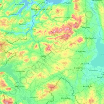
Name: Topografische Karte County Tyrone, Höhe, Relief.
Ort: County Tyrone, Northern Ireland, United Kingdom (54.32530 -7.92089 54.94534 -6.40659)
Durchschnittliche Höhe: 128 m
Minimale Höhe: -4 m
Maximale Höhe: 673 m
Andere topografische Karten
Klicken Sie auf eine Karte, um ihre Topografie, ihre Höhe und ihr Relief anzuzeigen.
Derry/Londonderry
United Kingdom > Northern Ireland > County Londonderry
Derry is characterised by its distinctively hilly topography. The River Foyle forms a deep valley as it flows through the city, making Derry a place of very steep streets and sudden, startling views. The original walled city of Londonderry lies on a hill on the west bank of the River Foyle. In the past, the…
Durchschnittliche Höhe: 88 m
Lagan Navigation (Abandoned)
United Kingdom > Northern Ireland > County Antrim > Belfast
Durchschnittliche Höhe: 29 m
Magheramorne
United Kingdom > Northern Ireland > County Antrim > Craigstown Meadow
Durchschnittliche Höhe: 32 m
Ederney
United Kingdom > Northern Ireland > County Fermanagh
By 1797, the settlement is recorded in the Topographia Hibernica as Ederny Bridge and "fair days" were held there.
Durchschnittliche Höhe: 91 m
Loughgiel Millennium Centre
United Kingdom > Northern Ireland > County Antrim > Loughguile
Durchschnittliche Höhe: 155 m
Castlecaufield
United Kingdom > Northern Ireland > County Tyrone > Castlecaulfield
Durchschnittliche Höhe: 95 m