
Topografische Karte Kinver Edge
Interaktive Karte
Klicken Sie auf die Karte, um die Höhe anzuzeigen.
Über diese Karte
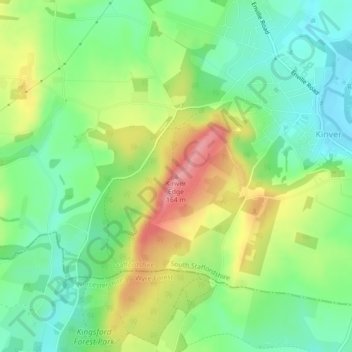
Name: Topografische Karte Kinver Edge, Höhe, Relief.
Durchschnittliche Höhe: 93 m
Minimale Höhe: 48 m
Maximale Höhe: 162 m
Andere topografische Karten
Klicken Sie auf eine Karte, um ihre Topografie, ihre Höhe und ihr Relief anzuzeigen.
Kinver
United Kingdom > England > South Staffordshire > Kinver
Kinver, South Staffordshire, Staffordshire, West Midlands, England, DY7 6HF, United Kingdom
Durchschnittliche Höhe: 81 m
Penkridge
United Kingdom > England > South Staffordshire > Penkridge
Penkridge, South Staffordshire, Staffordshire, West Midlands, England, ST19 5DJ, United Kingdom
Durchschnittliche Höhe: 104 m
Trysull and Seisdon
United Kingdom > England > South Staffordshire
Trysull and Seisdon, South Staffordshire, Staffordshire, West Midlands, England, United Kingdom
Durchschnittliche Höhe: 95 m
Baggeridge Country Park
United Kingdom > England > South Staffordshire
Baggeridge Country Park, Himley, South Staffordshire, Staffordshire, West Midlands, England, DY3 4HB, United Kingdom
Durchschnittliche Höhe: 146 m
Middle Pool
United Kingdom > England > South Staffordshire
Middle Pool, Crateford Lane, Brewood and Coven, South Staffordshire, Staffordshire, West Midlands, England, ST19 5PZ, United Kingdom
Durchschnittliche Höhe: 100 m
Shareshill
United Kingdom > England > South Staffordshire
Shareshill, South Staffordshire, Staffordshire, West Midlands, England, United Kingdom
Durchschnittliche Höhe: 123 m
Lapley, Stretton and Wheaton Aston
United Kingdom > England > South Staffordshire
Lapley, Stretton and Wheaton Aston, South Staffordshire, Staffordshire, West Midlands, England, United Kingdom
Durchschnittliche Höhe: 107 m