
Topografische Karte Pacific Palisades
Interaktive Karte
Klicken Sie auf die Karte, um die Höhe anzuzeigen.
Über diese Karte
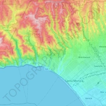
Name: Topografische Karte Pacific Palisades, Höhe, Relief.
Durchschnittliche Höhe: 196 m
Minimale Höhe: -2 m
Maximale Höhe: 653 m
Pacific Palisades was formally founded in 1921 by a Methodist organization, and in the years that followed became a refuge for Jewish artists and intellectuals fleeing the Holocaust. The Palisades would later be sought after by celebrities and other high-profile individuals seeking privacy. It is known for its seclusion and for being a close-knit community with a small-town feel, as well as its Mediterranean climate, hilly topography, natural environment, and abundance of parkland and hiking trails, 3-mile (4.8 km) strip of coastline, and for being home to a number of architecturally significant homes.
Andere topografische Karten
Klicken Sie auf eine Karte, um ihre Topografie, ihre Höhe und ihr Relief anzuzeigen.
Downtown
United States > California > Los Angeles County > Los Angeles
Downtown, Los Angeles, Los Angeles County, California, United States
Durchschnittliche Höhe: 84 m
Venice Beach
United States > California > Los Angeles County > Los Angeles
Venice Beach, Venice, Los Angeles, Los Angeles County, California, United States
Durchschnittliche Höhe: 4 m
San Fernando Valley
United States > California > Los Angeles County > Los Angeles
San Fernando Valley, Los Angeles, Los Angeles County, CAL Fire Contract Counties, California, 91406, United States
Durchschnittliche Höhe: 496 m
Thenard
United States > California > Los Angeles County > Los Angeles
Thenard, Los Angeles, Los Angeles County, CAL Fire Contract Counties, California, 90810, United States
Durchschnittliche Höhe: 8 m
Grand Park
United States > California > Los Angeles County > Los Angeles
Grand Park, Civic Center, Downtown, Los Angeles, Los Angeles County, CAL Fire Contract Counties, California, United States
Durchschnittliche Höhe: 103 m
Griffith Park
United States > California > Los Angeles County > Los Angeles
Griffith Park, Los Angeles, Los Angeles County, CAL Fire Southern Region, California, United States
Durchschnittliche Höhe: 221 m
Exposition Park
United States > California > Los Angeles County > Los Angeles
Exposition Park, Los Angeles, Los Angeles County, CAL Fire Southern Region, California, United States
Durchschnittliche Höhe: 55 m
Hollywood Hills
United States > California > Los Angeles County > Los Angeles
Hollywood Hills, Los Angeles, Los Angeles County, California, 90068, United States
Durchschnittliche Höhe: 242 m
Van Nuys
United States > California > Los Angeles County > Los Angeles
Van Nuys, Los Angeles, Los Angeles County, California, United States
Durchschnittliche Höhe: 228 m
Harbor City
United States > California > Los Angeles County > Los Angeles > Harbor Pines
Harbor City, Harbor Pines, Los Angeles, Los Angeles County, CAL Fire Contract Counties, California, 90717, United States
Durchschnittliche Höhe: 45 m
Rio de Los Angeles State Park State Recreational Area
United States > California > Los Angeles County > Los Angeles
Rio de Los Angeles State Park State Recreational Area, Lincoln Heights, Los Angeles, Los Angeles County, CAL Fire Contract Counties, California, United States
Durchschnittliche Höhe: 141 m