
Topografische Karte Côte-Nord-du-Golfe-du-Saint-Laurent
Interaktive Karte
Klicken Sie auf die Karte, um die Höhe anzuzeigen.
Über diese Karte
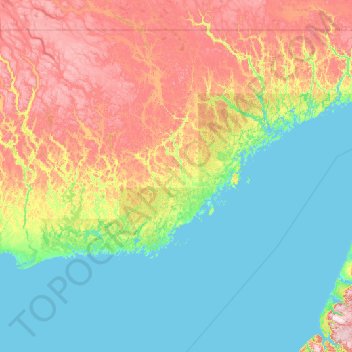
Name: Topografische Karte Côte-Nord-du-Golfe-du-Saint-Laurent, Höhe, Relief.
Durchschnittliche Höhe: 169 m
Minimale Höhe: -2 m
Maximale Höhe: 796 m
Andere topografische Karten
Klicken Sie auf eine Karte, um ihre Topografie, ihre Höhe und ihr Relief anzuzeigen.
Pakuashipi
Canada > Québec > Le Golfe-du-Saint-Laurent > Saint-Augustin
Pakuashipi, Saint-Augustin, Le Golfe-du-Saint-Laurent, Côte-Nord, Québec, Canada
Durchschnittliche Höhe: 64 m
Lac Long Pond
Canada > Québec > Le Golfe-du-Saint-Laurent > Bonne-Espérance
Lac Long Pond, Bonne-Espérance, Le Golfe-du-Saint-Laurent, Côte-Nord, Québec, Canada
Durchschnittliche Höhe: 110 m
Baie des Homards
Canada > Québec > Le Golfe-du-Saint-Laurent
Baie des Homards, Le Golfe-du-Saint-Laurent, Côte-Nord, Québec, Canada
Durchschnittliche Höhe: 55 m
Blanc-Sablon
Canada > Québec > Le Golfe-du-Saint-Laurent
Blanc-Sablon, Le Golfe-du-Saint-Laurent, Côte-Nord, Québec, Canada
Durchschnittliche Höhe: 98 m
Kegaska
Canada > Québec > Le Golfe-du-Saint-Laurent > Côte-Nord-du-Golfe-du-Saint-Laurent
Kegaska, Côte-Nord-du-Golfe-du-Saint-Laurent, Le Golfe-du-Saint-Laurent, Côte-Nord, Québec, Canada
Durchschnittliche Höhe: 6 m