
Topografische Karte Joué-lès-Tours
Interaktive Karte
Klicken Sie auf die Karte, um die Höhe anzuzeigen.
Über diese Karte
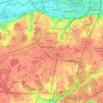
Name: Topografische Karte Joué-lès-Tours, Höhe, Relief.
Durchschnittliche Höhe: 81 m
Minimale Höhe: 41 m
Maximale Höhe: 101 m
Le Cher, d'une longueur totale de 365,5 km, prend sa source à 714 mètres d'altitude à Mérinchal, dans la Creuse et se jette dans la Loire à Villandry, à 40 m d'altitude, après avoir traversé 117 communes. Le Cher présente des fluctuations saisonnières de débit assez marquées. Sur le plan de la prévision des crues, la commune est située dans le tronçon du Cher tourangeau, dont la station hydrométrique de référence la plus proche est située à Tours [Pont Saint Sauveur]. Le débit mensuel moyen (calculé sur 53 ans pour cette station) varie de 25,8 m3/s au mois d'août à 192 m3/s au mois de février. Le débit instantané maximal observé sur cette station est de 1 000 m3/s le 24 mars 1988, la hauteur maximale relevée a été de 4,96 m le 5 juin 2016. Ce cours d'eau est classé dans les listes 1 et 2 au titre de l'article L. 214-17 du code de l'environnement sur le Bassin Loire-Bretagne. Au titre de la liste 1, aucune autorisation ou concession ne peut être accordée pour la construction de nouveaux ouvrages s'ils constituent un obstacle à la continuité écologique et le renouvellement de la concession ou de l'autorisation des ouvrages existants est subordonné à des prescriptions permettant de maintenir le très bon état écologique des eaux. Au titre de la liste 2, tout ouvrage doit être géré, entretenu et équipé selon des règles définies par l'autorité administrative, en concertation avec le propriétaire ou, à défaut, l'exploitant. Sur le plan piscicole, le Cher est classé en deuxième catégorie piscicole. Le groupe biologique dominant est constitué essentiellement de poissons blancs (cyprinidés) et de carnassiers (brochet, sandre et perche).
Andere topografische Karten
Klicken Sie auf eine Karte, um ihre Topografie, ihre Höhe und ihr Relief anzuzeigen.
Tours
France > Centre-Val de Loire > Indre-et-Loire
Tours, Indre-et-Loire, Centre-Val de Loire, France métropolitaine, France
Durchschnittliche Höhe: 73 m
La Ville
France > Centre-Val de Loire > Indre-et-Loire > Chinon > La Ville
La Ville, Chinon, Indre-et-Loire, Centre-Val de Loire, France métropolitaine, 37500, France
Durchschnittliche Höhe: 52 m
La Meslaie
France > Centre-Val de Loire > Indre-et-Loire > Beaumont-en-Véron
La Meslaie, Beaumont-en-Véron, Chinon, Indre-et-Loire, Centre-Val de Loire, France métropolitaine, 37420, France
Durchschnittliche Höhe: 51 m
La Fontaine
France > Centre-Val de Loire > Indre-et-Loire > Fondettes
La Fontaine, Fondettes, Tours, Indre-et-Loire, Centre-Val de Loire, France métropolitaine, 37230, France
Durchschnittliche Höhe: 67 m
Amboise
France > Centre-Val de Loire > Indre-et-Loire
Amboise, Loches, Indre-et-Loire, Centre-Val de Loire, France métropolitaine, 37400, France
Durchschnittliche Höhe: 91 m
Champigny-sur-Veude
France > Centre-Val de Loire > Indre-et-Loire
Champigny-sur-Veude, Chinon, Indre-et-Loire, Centre-Val de Loire, France métropolitaine, 37120, France
Durchschnittliche Höhe: 59 m
La Vicairerie
France > Centre-Val de Loire > Indre-et-Loire > Saint-Pierre-des-Corps
La Vicairerie, Saint-Pierre-des-Corps, Tours, Indre-et-Loire, Centre-Val de Loire, France métropolitaine, 37700, France
Durchschnittliche Höhe: 53 m
Le Bourg
France > Centre-Val de Loire > Indre-et-Loire > Truyes
Le Bourg, Truyes, Tours, Indre-et-Loire, Centre-Val de Loire, France métropolitaine, 37320, France
Durchschnittliche Höhe: 83 m
Chinon
France > Centre-Val de Loire > Indre-et-Loire
Chinon, Indre-et-Loire, Centre-Val de Loire, France métropolitaine, 37500, France
Durchschnittliche Höhe: 58 m
Couesmes
France > Centre-Val de Loire > Indre-et-Loire
Couesmes, Chinon, Indre-et-Loire, Centre-Val de Loire, France métropolitaine, 37330, France
Durchschnittliche Höhe: 90 m
Peuil
France > Centre-Val de Loire > Indre-et-Loire > Marcilly-sur-Vienne
Peuil, Marcilly-sur-Vienne, Chinon, Indre-et-Loire, Centre-Val de Loire, France métropolitaine, 37800, France
Durchschnittliche Höhe: 67 m
Les Navets
France > Centre-Val de Loire > Indre-et-Loire > Villandry
Les Navets, Villandry, Tours, Indre-et-Loire, Centre-Val de Loire, France métropolitaine, 37510, France
Durchschnittliche Höhe: 51 m
Le Papillon
France > Centre-Val de Loire > Indre-et-Loire > Parçay-Meslay
Le Papillon, Parçay-Meslay, Tours, Indre-et-Loire, Centre-Val de Loire, France métropolitaine, 37210, France
Durchschnittliche Höhe: 103 m
Ports-sur-Vienne
France > Centre-Val de Loire > Indre-et-Loire
Ports-sur-Vienne, Chinon, Indre-et-Loire, Centre-Val de Loire, France métropolitaine, 37800, France
Durchschnittliche Höhe: 63 m
Le Stade
France > Centre-Val de Loire > Indre-et-Loire > Montlouis-sur-Loire
Le Stade, Montlouis-sur-Loire, Tours, Indre-et-Loire, Centre-Val de Loire, France métropolitaine, 37270, France
Durchschnittliche Höhe: 59 m
Auzouer-en-Touraine
France > Centre-Val de Loire > Indre-et-Loire
Auzouer-en-Touraine, Loches, Indre-et-Loire, Centre-Val de Loire, France métropolitaine, 37110, France
Durchschnittliche Höhe: 112 m
Chaveignes
France > Centre-Val de Loire > Indre-et-Loire
Chaveignes, Chinon, Indre-et-Loire, Centre-Val de Loire, France métropolitaine, 37120, France
Durchschnittliche Höhe: 73 m
Ligueil
France > Centre-Val de Loire > Indre-et-Loire
Ligueil, Loches, Indre-et-Loire, Centre-Val de Loire, France métropolitaine, 37240, France
Durchschnittliche Höhe: 102 m
La Croix-en-Touraine
France > Centre-Val de Loire > Indre-et-Loire
La Croix-en-Touraine, Loches, Indre-et-Loire, Centre-Val de Loire, France métropolitaine, 37150, France
Durchschnittliche Höhe: 87 m
Pocé-sur-Cisse
France > Centre-Val de Loire > Indre-et-Loire
Pocé-sur-Cisse, Loches, Indre-et-Loire, Centre-Val de Loire, France métropolitaine, 37530, France
Durchschnittliche Höhe: 78 m
Saint-Branchs
France > Centre-Val de Loire > Indre-et-Loire
Saint-Branchs, Tours, Indre-et-Loire, Centre-Val de Loire, France métropolitaine, 37320, France
Durchschnittliche Höhe: 99 m
Véretz
France > Centre-Val de Loire > Indre-et-Loire
Véretz, Tours, Indre-et-Loire, Centre-Val de Loire, France métropolitaine, 37270, France
Durchschnittliche Höhe: 78 m
37420
France > Centre-Val de Loire > Indre-et-Loire > Avoine > Les Poires
37420, Les Poires, Avoine, Chinon, Indre-et-Loire, Centre-Val de Loire, France métropolitaine, France
Durchschnittliche Höhe: 37 m
Truyes
France > Centre-Val de Loire > Indre-et-Loire
Truyes, Tours, Indre-et-Loire, Centre-Val de Loire, France métropolitaine, 37320, France
Durchschnittliche Höhe: 85 m
Cangé
France > Centre-Val de Loire > Indre-et-Loire > Saint-Martin-le-Beau
Cangé, Saint-Martin-le-Beau, Loches, Indre-et-Loire, Centre-Val de Loire, France métropolitaine, 37270, France
Durchschnittliche Höhe: 74 m
Cormery
France > Centre-Val de Loire > Indre-et-Loire
Cormery, Loches, Indre-et-Loire, Centre-Val de Loire, France métropolitaine, 37320, France
Durchschnittliche Höhe: 83 m
Esvres
France > Centre-Val de Loire > Indre-et-Loire
Esvres, Tours, Indre-et-Loire, Centre-Val de Loire, France métropolitaine, 37320, France
Durchschnittliche Höhe: 86 m
Monnaie
France > Centre-Val de Loire > Indre-et-Loire
Monnaie, Tours, Indre-et-Loire, Centre-Val de Loire, France métropolitaine, 37380, France
Durchschnittliche Höhe: 122 m
Neuillé-Pont-Pierre
France > Centre-Val de Loire > Indre-et-Loire
Neuillé-Pont-Pierre, Chinon, Indre-et-Loire, Centre-Val de Loire, France métropolitaine, 37360, France
Durchschnittliche Höhe: 115 m
Savigné-sur-Lathan
France > Centre-Val de Loire > Indre-et-Loire
Savigné-sur-Lathan, Chinon, Indre-et-Loire, Centre-Val de Loire, France métropolitaine, 37340, France
Durchschnittliche Höhe: 89 m
Mazières-de-Touraine
France > Centre-Val de Loire > Indre-et-Loire
Mazières-de-Touraine, Chinon, Indre-et-Loire, Centre-Val de Loire, France métropolitaine, 37130, France
Durchschnittliche Höhe: 95 m
Gizeux
France > Centre-Val de Loire > Indre-et-Loire
Gizeux, Chinon, Indre-et-Loire, Centre-Val de Loire, France métropolitaine, 37340, France
Durchschnittliche Höhe: 78 m
Vallères
France > Centre-Val de Loire > Indre-et-Loire
Vallères, Tours, Indre-et-Loire, Centre-Val de Loire, France métropolitaine, 37190, France
Durchschnittliche Höhe: 76 m
Savigny-en-Véron
France > Centre-Val de Loire > Indre-et-Loire
Savigny-en-Véron, Chinon, Indre-et-Loire, Centre-Val de Loire, France métropolitaine, 37420, France
Durchschnittliche Höhe: 35 m
Les Doucets
France > Centre-Val de Loire > Indre-et-Loire > Maillé
Les Doucets, Maillé, Chinon, Indre-et-Loire, Centre-Val de Loire, France métropolitaine, 37800, France
Durchschnittliche Höhe: 59 m
Saint-Martin-le-Beau
France > Centre-Val de Loire > Indre-et-Loire
Saint-Martin-le-Beau, Loches, Indre-et-Loire, Centre-Val de Loire, France métropolitaine, 37270, France
Durchschnittliche Höhe: 78 m
Le Clos Bruneau
France > Centre-Val de Loire > Indre-et-Loire > Artannes-sur-Indre
Le Clos Bruneau, Artannes-sur-Indre, Tours, Indre-et-Loire, Centre-Val de Loire, France métropolitaine, 37260, France
Durchschnittliche Höhe: 74 m
Pouzay
France > Centre-Val de Loire > Indre-et-Loire
Pouzay, Chinon, Indre-et-Loire, Centre-Val de Loire, France métropolitaine, 37800, France
Durchschnittliche Höhe: 59 m
Ferrière-sur-Beaulieu
France > Centre-Val de Loire > Indre-et-Loire
Ferrière-sur-Beaulieu, Loches, Indre-et-Loire, Centre-Val de Loire, France métropolitaine, 37600, France
Durchschnittliche Höhe: 113 m
Le Vieux Cher
France > Centre-Val de Loire > Indre-et-Loire > Vallères
Le Vieux Cher, Vallères, Tours, Indre-et-Loire, Centre-Val de Loire, France métropolitaine, 37190, France
Durchschnittliche Höhe: 78 m
Civray-de-Touraine
France > Centre-Val de Loire > Indre-et-Loire
Civray-de-Touraine, Loches, Indre-et-Loire, Centre-Val de Loire, France métropolitaine, 37150, France
Durchschnittliche Höhe: 96 m
Le Bois Gaudy
France > Centre-Val de Loire > Indre-et-Loire > Boussay
Le Bois Gaudy, Boussay, Loches, Indre-et-Loire, Centre-Val de Loire, France métropolitaine, 37290, France
Durchschnittliche Höhe: 107 m
La Croix Billard
France > Centre-Val de Loire > Indre-et-Loire > La Tour-Saint-Gelin
La Croix Billard, La Tour-Saint-Gelin, Chinon, Indre-et-Loire, Centre-Val de Loire, France métropolitaine, 37120, France
Durchschnittliche Höhe: 97 m
Le Buisson
France > Centre-Val de Loire > Indre-et-Loire > Tauxigny-Saint-Bauld
Le Buisson, Tauxigny, Tauxigny-Saint-Bauld, Loches, Indre-et-Loire, Centre-Val de Loire, France métropolitaine, 37310, France
Durchschnittliche Höhe: 97 m
La Guilbertière
France > Centre-Val de Loire > Indre-et-Loire > Couesmes
La Guilbertière, Couesmes, Chinon, Indre-et-Loire, Centre-Val de Loire, France métropolitaine, 37330, France
Durchschnittliche Höhe: 114 m
Les Jardins des Prés Michau
France > Centre-Val de Loire > Indre-et-Loire > Ligueil
Les Jardins des Prés Michau, Ligueil, Loches, Indre-et-Loire, Centre-Val de Loire, France métropolitaine, 37240, France
Durchschnittliche Höhe: 97 m
Le Point du Jour
France > Centre-Val de Loire > Indre-et-Loire > Sonzay
Le Point du Jour, Sonzay, Chinon, Indre-et-Loire, Centre-Val de Loire, France métropolitaine, 37360, France
Durchschnittliche Höhe: 116 m
L'Autoroute
France > Centre-Val de Loire > Indre-et-Loire > Monnaie
L'Autoroute, Monnaie, Tours, Indre-et-Loire, Centre-Val de Loire, France métropolitaine, 37380, France
Durchschnittliche Höhe: 119 m
Le Château
France > Centre-Val de Loire > Indre-et-Loire > Véretz
Le Château, Véretz, Tours, Indre-et-Loire, Centre-Val de Loire, France métropolitaine, 37270, France
Durchschnittliche Höhe: 71 m
Mettray
France > Centre-Val de Loire > Indre-et-Loire
Mettray, Tours, Indre-et-Loire, Centre-Val de Loire, France métropolitaine, 37390, France
Durchschnittliche Höhe: 85 m