
Topografische Karte Intibucá
Interaktive Karte
Klicken Sie auf die Karte, um die Höhe anzuzeigen.
Über diese Karte
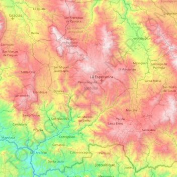
Name: Topografische Karte Intibucá, Höhe, Relief.
Ort: Intibucá, Honduras (13.84856 -88.51109 14.65781 -87.84765)
Durchschnittliche Höhe: 1.151 m
Minimale Höhe: 54 m
Maximale Höhe: 2.369 m
Andere topografische Karten
Klicken Sie auf eine Karte, um ihre Topografie, ihre Höhe und ihr Relief anzuzeigen.
Yamaranguila
Honduras > Intibucá > Yamaranguila
Yamaranguila, Intibucá, Honduras
Durchschnittliche Höhe: 1.753 m
Cerro El Pelón
Honduras > Intibucá > La Esperanza
Cerro El Pelón, La Esperanza, Intibucá, Honduras
Durchschnittliche Höhe: 1.913 m
La Esperanza
Honduras > Intibucá > La Esperanza
La Esperanza, Intibucá, Honduras
Durchschnittliche Höhe: 1.534 m
Jesús de Otoro
Honduras > Intibucá > Jesús de Otoro
Jesús de Otoro, Intibucá, Honduras
Durchschnittliche Höhe: 741 m
Río Guarajambala
Honduras > Intibucá > La Esperanza
Río Guarajambala, La Esperanza, Intibucá, Honduras
Durchschnittliche Höhe: 489 m