
Topografische Karte Machilipatnam
Interaktive Karte
Klicken Sie auf die Karte, um die Höhe anzuzeigen.
Über diese Karte
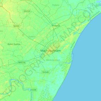
Name: Topografische Karte Machilipatnam, Höhe, Relief.
Ort: Machilipatnam, Krishna, Andhra Pradesh, 521001, India (16.02174 80.97482 16.34174 81.29482)
Durchschnittliche Höhe: 4 m
Minimale Höhe: -4 m
Maximale Höhe: 13 m
Machilipatnam city is at 16°10′N 81°08′E / 16.17°N 81.13°E / 16.17; 81.13 on the southeast coast of India and in the east coast of Andhra Pradesh.[18] The city has an average elevation of 14 meters (45 feet).[19]