
Topografische Karte Hiawassee
Interaktive Karte
Klicken Sie auf die Karte, um die Höhe anzuzeigen.
Über diese Karte
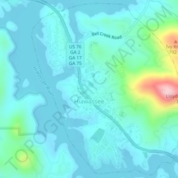
Name: Topografische Karte Hiawassee, Höhe, Relief.
Ort: Hiawassee, Towns County, Georgia, United States (34.93679 -83.76766 34.96284 -83.73950)
Durchschnittliche Höhe: 620 m
Minimale Höhe: 581 m
Maximale Höhe: 843 m
Andere topografische Karten
Klicken Sie auf eine Karte, um ihre Topografie, ihre Höhe und ihr Relief anzuzeigen.
Macedonia
United States > Georgia > Towns County
Macedonia, Towns County, Georgia, 30546, United States
Durchschnittliche Höhe: 637 m
Young Harris
United States > Georgia > Towns County
Young Harris, Towns County, Georgia, United States
Durchschnittliche Höhe: 606 m
Friendship
United States > Georgia > Towns County > Friendship
Friendship, Towns County, Georgia, United States
Durchschnittliche Höhe: 625 m
Brasstown Bald
United States > Georgia > Towns County
Brasstown Bald, Towns County, Georgia, United States
Durchschnittliche Höhe: 1.161 m