
Topografische Karte Wickersley
Interaktive Karte
Klicken Sie auf die Karte, um die Höhe anzuzeigen.
Über diese Karte
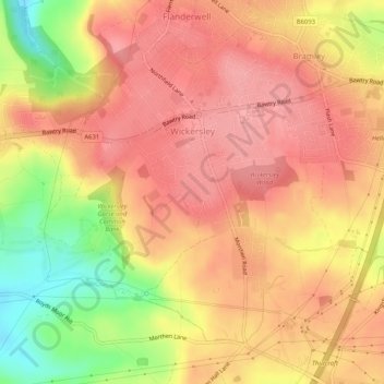
Name: Topografische Karte Wickersley, Höhe, Relief.
Durchschnittliche Höhe: 116 m
Minimale Höhe: 50 m
Maximale Höhe: 148 m
Andere topografische Karten
Klicken Sie auf eine Karte, um ihre Topografie, ihre Höhe und ihr Relief anzuzeigen.
Catcliffe
United Kingdom > England > Rotherham
The Catcliffe Glass Cone, part of the previous William Fenney's glassworks, is on Main Street. The centre of the village is dominated by a nine-arch viaduct that was built in 1901 to carry the Sheffield District Railway across the River Rother. Catcliffe Flash, to the south of the village, is a local nature…
Durchschnittliche Höhe: 58 m
Sheffield and South Yokshire Navigation
United Kingdom > England > Rotherham > Thrybergh
Durchschnittliche Höhe: 39 m
Kiveton Park
United Kingdom > England > Rotherham
Kiveton Park is located at approximately 53°20′30″N 1°15′30″W / 53.34167°N 1.25833°W / 53.34167; -1.25833, at an elevation of around 330 feet (100 m) above sea level, and is located 8 miles (13 km) west of Worksop, and 11 miles (18 km) south-east of both Sheffield, and Rotherham…
Durchschnittliche Höhe: 104 m
Wales
United Kingdom > England > Rotherham
The village of Wales itself is located at approximately 53°20′30″N 1°16′45″W / 53.34167°N 1.27917°W / 53.34167; -1.27917, at an elevation of around 300 feet (100 m) above sea level. It lies on the A618 and B6059 roads. The M1 motorway bisects the parish, while the southern boundary is…
Durchschnittliche Höhe: 95 m
Carr
United Kingdom > England > Rotherham > Laughton-en-le-Morthen > Carr
Durchschnittliche Höhe: 112 m
Treeton
United Kingdom > England > Rotherham
Catcliffe Flash, to the west of the village, is a local nature reserve that is made up of a lake and marshland formed as the elevation of the land beside the River Rother dropped due to coal mining subsidence. To the south-east of the village are three areas of ancient woodland, Treeton Wood, Hail Mary Hill…
Durchschnittliche Höhe: 58 m