
Topografische Karte Downpatrick
Interaktive Karte
Klicken Sie auf die Karte, um die Höhe anzuzeigen.
Über diese Karte
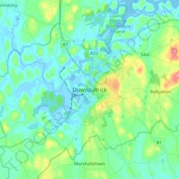
Name: Topografische Karte Downpatrick, Höhe, Relief.
Durchschnittliche Höhe: 25 m
Minimale Höhe: -9 m
Maximale Höhe: 119 m
Andere topografische Karten
Klicken Sie auf eine Karte, um ihre Topografie, ihre Höhe und ihr Relief anzuzeigen.
County Antrim
United Kingdom > Northern Ireland
A large portion of Antrim is hilly, especially in the east, where the highest elevations are attained. The range runs north and south, and, following this direction, the highest points are Knocklayd 514 m (1,690 ft), Slieveanorra 508 m (1,670 ft), Trostan 550 m (1,800 ft), Slemish 437 m (1,430 ft), Agnew's…
Durchschnittliche Höhe: 70 m
Ballycullen
United Kingdom > Northern Ireland > County Down > Newtownards > Ballycullen
Durchschnittliche Höhe: 49 m
Lagan Navigation (Abandoned)
United Kingdom > Northern Ireland > County Antrim > Belfast
Durchschnittliche Höhe: 29 m
County Antrim
United Kingdom > Northern Ireland
A large portion of Antrim is hilly, especially in the east, where the highest elevations are attained. The range runs north and south, and, following this direction, the highest points are Knocklayd 514 m (1,690 ft), Slieveanorra 508 m (1,670 ft), Trostan 550 m (1,800 ft), Slemish 437 m (1,430 ft), Agnew's…
Durchschnittliche Höhe: 70 m
Tollymore Forest
United Kingdom > Northern Ireland > County Down > Bryansford
Durchschnittliche Höhe: 163 m
Loughgiel Millennium Centre
United Kingdom > Northern Ireland > County Antrim > Loughguile
Durchschnittliche Höhe: 155 m
Castlecaufield
United Kingdom > Northern Ireland > County Tyrone > Castlecaulfield
Durchschnittliche Höhe: 95 m
Rathlin Island
United Kingdom > Northern Ireland > County Antrim > Church Bay
Durchschnittliche Höhe: 10 m
Shane's Castle Park
United Kingdom > Northern Ireland > County Antrim > Randalstown
Durchschnittliche Höhe: 30 m
Ballymartin
United Kingdom > Northern Ireland > County Down > Ballymartin
Durchschnittliche Höhe: 29 m
Ballymagroarty
United Kingdom > Northern Ireland > County Londonderry > Derry/Londonderry
Durchschnittliche Höhe: 73 m
Ballygomartin
United Kingdom > Northern Ireland > County Antrim > Belfast
Durchschnittliche Höhe: 258 m
Botanic Gardens
United Kingdom > Northern Ireland > County Antrim > Belfast
Durchschnittliche Höhe: 15 m
Lower Lough Erne
United Kingdom > Northern Ireland > Enniskillen > Lisnarrick
Durchschnittliche Höhe: 96 m
Stormont Estate
United Kingdom > Northern Ireland > County Down > Dundonald
Durchschnittliche Höhe: 64 m
Lagan Valley AONB
United Kingdom > Northern Ireland > County Down > Ballyskeagh
Durchschnittliche Höhe: 66 m