
Topografische Karte Oldmilltown
Interaktive Karte
Klicken Sie auf die Karte, um die Höhe anzuzeigen.
Über diese Karte
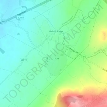
Name: Topografische Karte Oldmilltown, Höhe, Relief.
Durchschnittliche Höhe: 154 m
Minimale Höhe: 114 m
Maximale Höhe: 247 m
Andere topografische Karten
Klicken Sie auf eine Karte, um ihre Topografie, ihre Höhe und ihr Relief anzuzeigen.
The Municipal District of Kilkenny City
The Municipal District of Kilkenny City, Condado de Kilkenny, Leinster, Irlanda
Durchschnittliche Höhe: 84 m
West Clare Municipal District
West Clare Municipal District, Condado de Clare, Munster, Irlanda
Durchschnittliche Höhe: 37 m
The Municipal District of Naas
The Municipal District of Naas, County Kildare, Leinster, Irlanda
Durchschnittliche Höhe: 152 m
Churchtown-Orwell ED
Churchtown-Orwell ED, Dublin 14, Dún Laoghaire-Rathdown, County Dublin, Leinster, Irlanda
Durchschnittliche Höhe: 54 m
Cherry Orchard
Cherry Orchard, Merchants Quay E ED, Dublin 8, Dublin, County Dublin, Leinster, Irlanda
Durchschnittliche Höhe: 25 m