
Topografische Karte Barton Stacey
Interaktive Karte
Klicken Sie auf die Karte, um die Höhe anzuzeigen.
Über diese Karte
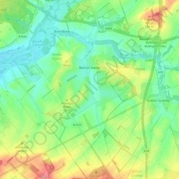
Name: Topografische Karte Barton Stacey, Höhe, Relief.
Ort: Barton Stacey, Test Valley, Hampshire, England, United Kingdom (51.12413 -1.42653 51.19000 -1.35076)
Durchschnittliche Höhe: 75 m
Minimale Höhe: 43 m
Maximale Höhe: 132 m
Andere topografische Karten
Klicken Sie auf eine Karte, um ihre Topografie, ihre Höhe und ihr Relief anzuzeigen.
Bath Meadows
United Kingdom > England > Hampshire > Test Valley > Wellow > East Wellow
Durchschnittliche Höhe: 30 m
News Wood
United Kingdom > England > Hampshire > Test Valley > King's Somborne
Durchschnittliche Höhe: 93 m
Drayton
United Kingdom > England > Hampshire > Test Valley > Barton Stacey
Durchschnittliche Höhe: 61 m
Dunbridge
United Kingdom > England > Hampshire > Test Valley > Mottisfont
Durchschnittliche Höhe: 43 m
Fullerton
United Kingdom > England > Hampshire > Test Valley > Chilbolton
Durchschnittliche Höhe: 64 m
Withering Corner
United Kingdom > England > Hampshire > Test Valley > Ashley
Durchschnittliche Höhe: 120 m
Winton Hill
United Kingdom > England > Hampshire > Test Valley > Stockbridge
Durchschnittliche Höhe: 73 m
Bitterne Grove
United Kingdom > England > Hampshire > Test Valley > Mottisfont > Dunbridge
Durchschnittliche Höhe: 39 m
Little Ann
United Kingdom > England > Hampshire > Test Valley > Anna Valley
Durchschnittliche Höhe: 77 m
Rockmoor Pond
United Kingdom > England > Hampshire > Test Valley > Littledown
Durchschnittliche Höhe: 208 m
Clanville
United Kingdom > England > Hampshire > Test Valley > Appleshaw
Durchschnittliche Höhe: 107 m
Charlton Down
United Kingdom > England > Hampshire > Test Valley > Wildhern > Charlton Down
Durchschnittliche Höhe: 111 m
Palestine
United Kingdom > England > Hampshire > Test Valley > Palestine
Durchschnittliche Höhe: 109 m
Faberstown
United Kingdom > England > Hampshire > Test Valley > Faberstown
Durchschnittliche Höhe: 124 m
The Bog
United Kingdom > England > Hampshire > Test Valley > Braishfield > Crookhill
Durchschnittliche Höhe: 39 m