Geolokalisieren

Topografische Karte Victoria Dock

Interaktive Karte

Klicken Sie auf die Karte, um die Höhe anzuzeigen.

Über diese Karte

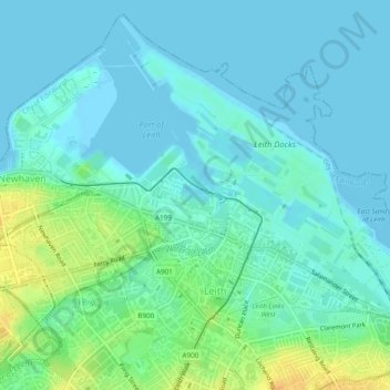
Name: Topografische Karte Victoria Dock, Höhe, Relief.

Ort: Victoria Dock, Edinburgh, City of Edinburgh, Scotland, United Kingdom (55.97848 -3.17520 55.97985 -3.17160)

Durchschnittliche Höhe: 7 m

Minimale Höhe: -1 m

Maximale Höhe: 27 m

Andere topografische Karten

Klicken Sie auf eine Karte, um ihre Topografie, ihre Höhe und ihr Relief anzuzeigen.

Edinburgh

United Kingdom > Scotland > Edinburgh

Some have called Edinburgh the Athens of the North for a variety of reasons. The earliest comparison between the two cities showed that they had a similar topography, with the Castle Rock of Edinburgh performing a similar role to the Athenian Acropolis. Both of them had flatter, fertile agricultural land…

Durchschnittliche Höhe: 104 m

Leith Links

United Kingdom > Scotland > Edinburgh

Durchschnittliche Höhe: 15 m

Firth of Forth

United Kingdom > Scotland > Edinburgh

Durchschnittliche Höhe: 87 m

Blackford Hill

United Kingdom > Scotland > Edinburgh

Durchschnittliche Höhe: 105 m

Liberton and District

United Kingdom > Scotland > Edinburgh

Durchschnittliche Höhe: 116 m

Mayfield

United Kingdom > Scotland > Edinburgh

Durchschnittliche Höhe: 80 m

Duddingston Loch

United Kingdom > Scotland > Edinburgh

Durchschnittliche Höhe: 64 m

Leith Harbour & Newhaven

United Kingdom > Scotland > Edinburgh

Durchschnittliche Höhe: 7 m

Figgate Pond

United Kingdom > Scotland > Edinburgh

Durchschnittliche Höhe: 25 m

Lochend Loch

United Kingdom > Scotland > Edinburgh

Durchschnittliche Höhe: 34 m

Torduff Hill

United Kingdom > Scotland > Edinburgh

Durchschnittliche Höhe: 224 m